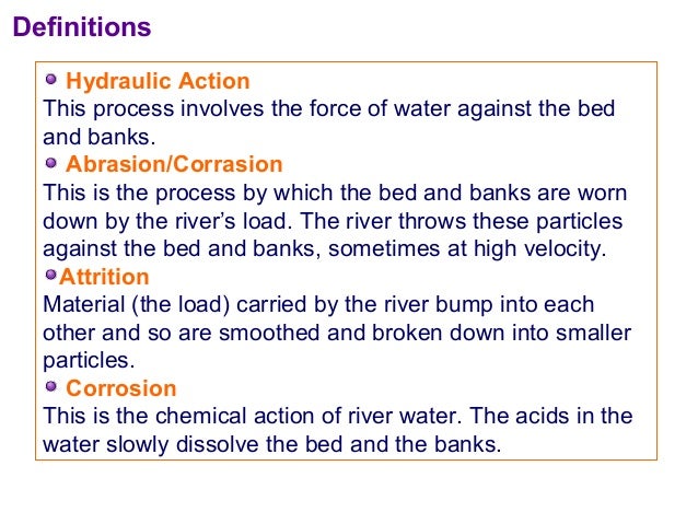
Drainage basin The area drained by a river and its tributaries.
Drainage divide Also known as a watershed, it is the line defining the boundary of a river or stream drainage basin separating it from adjacent basin(s).
Maximum sustainable The maximum level of extraction of water that can be maintained
yield indefinitely for a given area.
Wetlands Areas that are regularly saturated by surface water or groundwater, including freshwater marshes, swamps and bogs.
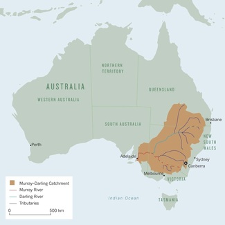
Although the Murray-Darling is Australia's longest river system, draining a basin the size of France and Spain combined, it no longer carries enough water to carve its own path to the sea. After 10 years of drought, and many more years of overexploitation and pollution, the only hope of restoring the river to health lies in a complete overhaul of how it is managed.
Droughts have long plagued the Murray-Darling and Australia's population continue to grow along with the demand for water in the cities and for the crops that grow in the river basin. By 1994 human activity was consuming 77% of the river's annual flow. Thanks to a combination of of reduced flow and increased run-off from saline soils churned up by agriculture, the water was becoming unhealthily salty, especially in its lower reaches. The tap water in Adelaide was beginning to taste saline.
Australia embarked on a series of reforms that in many ways serve as a model for the management of big, heavily exploited rivers. New South wales, Victoria and South Australia agreed to cap the amount of water they took from the river. they also made plans to reduce salinity and increase "environmental flows". They agreed on the following reforms:
There would be no more subsides for irrigation.
Farmers would be responsible for the maintenance of channels and dams.
For each river and tributary, scientists would calculate the maximum sustainable allocations of water, and states would make sure that extractions did not exceed that figure.
Guided by these principles, the states have made much progress. By 1999 the average salinity of the river in South Australia had fallen by over 20%. The construction of fish ladders around dams and weirs, and the release of extra water into important breeding grounds has spawned a recovery in native species.
However, many problems remain. Farmers in certain states can still drill wells to suck up groundwater, and tree plantations absorb much of the rainwater that would otherwise find its way to the river. Small dams on farms, which block small streams or trap run-off from rain or flooding, also prevent water from reaching the river.
Source: Nagle, Garrett and Briony Cooke. Geography Course Companion. Print.
Conflicts at the international scale - River Jordan Drainage Basin and the Mountain Aquifer, Jordan, Israel and Palestine
The River Jordan is 251km in length. The source of the River Jordan is in the Anti-Lebanon mountains. It then travels south from Lebanon, along the border of Syria and Israel, before entering the Sea of Galilee (Lake Tiberias). The river then forms the border of Israel and Jordan, followed by the West Bank (Palestine) and Jordan before having its mouth in the Dead Sea. The Dead Sea is unusual because of its high salt content and low elevation. It is about 400 metres below sea level (the lowest place on the surface of the earth).
Three main tributaries join north of the Sea of Galilee to form the River Jordan. They are:
The Hasbani, which rises in south Lebanon, with an average annual flow of 138 million cubic metres,
The Dan River, in Israel, averaging 245 million cubic metres per year, and
The Banias River flowing from the Golan Heights, averaging 121 million cubic metres per year.
The climate around Israel, Jordan, Palestine and Syria is very arid (much of Jordan and Syria is desert). The dry climate and the growing populations of the five countries along the River Jordan would be enough to cause conflict over the use of the River Jordan. However, if you add the political and religious disagreements of the area, conflict over the River Jordan is likely to increase in the future.
West Bank - Mountain Aquifer
Apart from the River Jordan, the mountain aquifer, largely found in Palestinian territory is the main source of water in Israel and the West Bank. The mountain aquifer in the occupied West Bank is largely used by Israel (80%), only leaving 20% for the Palestinians. The Israel's claim that they have the right to use the aquifer, because some of the water flows (groundwater flow or base flow) into Israeli territory. The coastal aquifer shown to the right (in the Gaza Strip - also part of the Palestinian territory), is becoming exhausted and at threat from saltwater intrusion as well as domestic and industrial pollution.
Within the West Bank, you find Palestinians and Israeli's living in illegal settlements. The graph below shows that the level of water consumption among Israeli's and Palestinian's living in the territory is very uneven. On average Israeli's consume nearly 300 liters and Palestinians about 70 liters.
Dam: a barrier constructed to hold back water and raise its level, forming a reservoir used to generate electricity or as a water supply.
Reservoir: a large natural or artificial lake used as a source of water supply.
Multipurpose scheme: a scheme or project built for more than one purpose. For example to prevent flooding as well as irrigate the land and also generate HEP
Increased evaporation rates because reservoirs have a larger surface area than rivers.
An increase in the amount of surface store (reservoirs are an artificial store).
A reduction in the velocity of the river upstream. The river was effectively flowing into a stationary store of water.
Increased sedimentation can lower the depth of the river and the reservoir. Again this will reduce velocity and may also reduce storage capacity.
River discharge will decrease because water is being held behind the dam.
A rivers' discharge may become more regular (less extremes) because the flow of water is regulated.
Clear water erosion may cause the bed of the river to lower. There is no sediment (load) to be deposited to replace erosion.
The amount of load transported by the river will reduce because less sediment is reaching downstream.
The salinity of the water and the ground may increase.
The temperature of the water may reduce, as water released from reservoirs is often colder (reservoir deeper than river).
The water may also be less oxygenated than natural free flowing water.
With smaller discharge the velocity of the river may decrease, because the level of the river is further below bankfull discharge so the hydraulic radius is smaller.
The amount of depositional landforms may reduce e.g. alluvial fans, levees, deltas and slip off slopes.
Aswan High Dam is a rock-fill dam located at the northern border between Egypt and Sudan. The dam is fed by the River Nile's waters, and the reservoir created by the dam forms Lake Nasser.
The dam's construction began in 1960 and was completed in 1968. It was, however, officially inaugurated in 1971. The total investment for constructing the dam reached $1bn.
With a reservoir capacity of 132 cubic kilometres, the Aswan High Dam provides water for about 33,600km of irrigation land. It serves the irrigation needs of both Egypt and Sudan, controls flooding, generates power and helps in improving navigation across the Nile.
Egypt and Sudan reached an agreement in 1959, as part of which about 18.5 cubic kilometres of water from the reservoir was allocated to Sudan.
The building of the dam has allowed farming to continue, even during drought years e.g. 1972 and 1973. This reduces the dependency on food imports.
Up to 3.4 million hectares have been irrigated by the Nile, increasing the agriculture output of Egypt.
The hydroelectric power accounts for 45% of Egypt's energy needs. This figure will obviously reduce as the Egyptian economy develops and the size of the Egyptian population increases.
The dam has improved navigation upstream and downstream, Lake Nasser is now easily navigated and there are less seasonal variations downstream as the amount of water released is regulated.
The improvement in navigation has increased tourism on the River Nile. The dam itself has become an important tourist attraction along with the temples that line the river.
The amount of fishing behind the dam in Lake Nasser has increased supporting the local fishing industry.
The flood control of the dam saved lives in 1965, 1965, 1975 and 1987. Also less flooding means that there are no flood repair costs and insurance premiums are also cheaper.
The building and maintenance of the dam has created many jobs and taught local workers new skills.
Up to 100,000 Nubian (indigenous Egyptians) were forced to move from their ancestral homes.
Evaporation of water has increased with the construction of the Aswan Dam and Lake Nasser. It is estimated that about 10% of the water is lost through evaporation.
Deposition of sediment within Lake Nasser is estimated at 100 million tonnes each year. The increased sedimentation may put stress on the dam, reduce the depth of the lake and therefore the amount it can store and also prevent the nutrients from reaching farmland downstream.
There has been some increase in clear water erosion below the dam i.e. erosion is still taking place but there is no deposition to replace the eroded material.
The Nile delta is eroding at 25mm a year (no sediment to be deposited). This might sound a small amount, but the erosion maybe further compounded by rising sea levels.
It is estimated that $100 million worth of artificial fertilisers have to be used every year to replace the nutrients (alluvium) trapped behind the dam. This obviously has an economic cost, but there is also the environmental cost of using chemicals and possibly the social cost of people consuming the chemicals.
The changing ecosystems have reduced the amount of fish (overfishing and rising population also play a part) being caught. Sardine yields are down by 95% causing 3,000 jobs to be lost.
The increase in the amount of standing water has increased the amount of mosquitoes and the diseases that they carry e.g. malaria and dengue.
Fertile agricultural land in Sudan was lost that Egypt had to pay compensation for.
Poor management has increased the salinity of the water and soil. This has reduced crop yields by up to one third in some areas.
Fertilisers, chemicals and waste is no longer flushed away by the Nile's annual floods.
Archeological sites were either lost or had to be moved with the flooding of Lake Nasser e.g. Abu Simbel Temple.
The total cost of building the dam was estimated at about $1 billion.
Currently Egypt and Sudan get 90% of the Nile's water. Other countries that the Nile floes through are unhappy and have asked for more. This could lead to conflict or the amount of water Egypt receives, reducing. East Africa Countries Seek More Nile Water from Egypt - BBC article
The weight of the dam and the reservoir has increased the amount of seismic stress in the area. Egypt's earthquake in November 1981 was actually blamed on the dam
Channel Enlargement (widening/deepening):Making the width and depth of the river wider
and deeper to increase its cross-sectional area.
Advantages: By enlarging the cross-sectional area
you are increasing the bankfull discharge of the river along with its
hydraulic radius. This will increase the velocity of the river and reduce the
chances of it flooding in the immediate area by moving the floodwater further
on downstream.
Disadvantages: If buildings are built up to the river
bank it might not be possible to enlarge the channel. Also the process can be
expensive and can cause problems to areas downstream who are receiving more
flood water quicker, but with an un-enlarged channel.
Channel Straightening: Removing meanders from a river to make
the river straighter.
Advantages: By removing meanders the velocity of the
water through a settlement will increase. This will stop a backlog of water
and should reduce the risk of flooding. It also improves navigation.
Disadvantages: By changing the course of the river, you
might remove flowing water from industries that depend on it. There might
also be building that have to be demolished to allow straightening. Again it
is expensive and may cause flooding problems downstream.
Flood Relief Channels: Building new artificial channels that
are used when a river nears bankfull discharge.
Advantages: They take the pressure off the main
channels when floods are likely therefore reduce flood risk.
Disadvantages: It can be hard find land to build relief
channels, they are expensive and when empty can become areas to dump rubbish,
etc. If river levels rise significantly it is also possible for relief
channels to flood as well.
Artificial Stores: Creating reservoirs or lakes that can
store excess water in times of flood.
Advantages: They can remove pressure of the main
channel and can become new habitats and serve other purposes e.g. leisure,
drinking water.
Disadvantages: Building dams, sluices, diversion
channels are all expensive. They also involve flooding areas of land which
may be hard to find near large vulnerable urban populations.
Flood Embankments
(levees): Like levees
these increase the channel depth of a river, raising its bankfull discharge
and reducing the risk of flood.
Advantages: They increase the cross-sectional area
of the river and therefore its hydraulic radius. This should reduce the risk
of flooding.
Disadvantages: Like in New Orleans under extreme
conditions, embankments may fail causing even bigger problems. They are
expensive to build and again may cause problems downstream.
Controlled Flooding: Allowing low value land e.g. farmland to
flood, therefore protecting higher value areas.
Advantages: By allowing the river to flood naturally
you are taking the pressure of high value areas, you are letting the river
behave more naturally and it adds alluvium to the floodplain.
Disadvantages: You have to make the decision what is
worth protecting which is always going to upset someone. You also have to
protect areas that you don't want to flood which costs money (cost benefit
analysis)
Afforestation /
Reforestation:Simply planting more
trees in a drainage basin.
Advantages: This is a natural process, increasing
the amount of interception, transpiration and root uptake. People would not
normally protest against trees being planted.
Disadvantages: It is not possible to cover the whole
drainage basin in trees, so if it rains in an area with no trees, then there
is no reduction in flooding. Also most trees lose there leaves in autumn and
winter reducing interception in those months.
Flood Proofing: This is making property less vulnerable
to flooding or flood damage. This might be temporary like using sandbags or
design by removing carpets downstairs.
Advantages: This can be done on an individual level
and can be relatively cheap. Temporary protection can be removed under normal
circumstances so it does not change the aesthetics of properties.
Disadvantages: Temporary defences can usually only protect
against minor floods. Not everyone will be happy with having to redesign
their houses.
Insurance: Although it doesn't prevent flooding, it
can help individuals and industries to recover and protect against future
flooding.
Advantages: It helps individuals and settlements to
recover after flood events and may help them protect property and be less
vulnerable in the future.
Disadvantages: They do not actually prevent flooding.
Not everyone can afford insurance and insurance companies may not insure high
risk areas.
Land Use Planning
(zoning): Mapping areas by
looking at there likelihood to flood and then only building low value uses on
areas with high flood risk.
Advantages: Very good at removing high value areas
and high density populations from hazardous areas.
Disadvantages: It is not always possible to change land
uses that already exist in an area. You have to decide what size flood to map
for e.g. a once in ten year flood or once in one hundred year flood. Often
poor will still choose to live on marginal land.
Contour Ploughing and
Strip Cultivation: Either ploughing
with the contours creating temporary surface stores or leaving vegetation to
increase interception and transpiration
Advantages: Contour ploughing is simply a cheap and
easy change in existing farming methods, Keeping vegetation is natural and
relatively cheap.
Disadvantages: Won't protect against big floods and
farmers may not be happy giving up farmland, simply to grow trees.
Interception Channels: These are channels that divert a rivers'
discharge around settlements. The old channel remains but with a smaller
discharge.
Advantages: They remove pressure of the main river
and areas of high land value. They may also develop into new habitats for
plants and animals.
Disadvantages: They are expensive, may flood themselves
in times of heavy floods and may restrict future urban
Settlement Removal: Moving settlements from high risk flood
areas to less vulnerable locations often on higher land.
Advantages: Is probably the most effective because
you remove high value property and humans from vulnerable areas.
Disadvantages: It is usually not practical to move
whole settlements, because of the cost and the problems of finding
alternative locations. Also many settlements depend on water for their
survival.
Dams: Often built as part of a multipurpose
scheme, they create artificial stores which can hold water in times of
increased precipitation.
Advantages: They can store large amounts of water
and can be used for other purposes.
Disadvantages: If rain is downstream of the dam then
they have no effect. In large flood events they are vulnerable to breaking
and are expensive to build.
Wing Dykes: Barriers placed out into a river, these
can be used to divert the cause of rivers by shifting the thalweg of rivers.
This may move the channel away from high value areas.
Advantages: They can move the main channel from
vulnerable areas to protect high value areas.
Disadvantages: They are expensive to build and during
big flood events the flood water may go over the wing dykes. Also if there is
property on both sides of a river, which side do you protect.
Electronically
Controlled Sewers: Advanced sewers
which can control the flow of rain water to stop increased discharge into
rivers and therefore flooding.
Advantages: They can be very effective at
controlling smaller floods. They are underground so do not cause any visual
pollution.
Disadvantages: This involves a complete redesign of
sewers. Sewers usually have to be increased in size and electronic sluices
have to be added. They also have to be operated from a central command centre
and with all electronically operated equipment can break. Also they might not
be able to cope with large scale floods, so water has to be released into
rivers anyway.
Channelisation: The concreting of beds and banks.
Advantages: Reduces friction and increases velocity
of river, removing water from the channelised area quicker. Bank erosion is
also reduced.
Disadvantages: It is expensive and is not natural so
vegetation and animal life will find it harder to grow and live. Flooding
maybe caused downstream of the channelised area.
Dredging: The removal of material from the bed of
the river deepening it.
Advantages: Channel cross-section is increased so
the river can hold greater discharge. It can look more natural because no
structures are built.
Disadvantages: Deposition can mean that dredging needs
to happen regularly.
River bank
conservation: Protecting the banks
and sides of the river to reduce erosion. This can be done through planting
vegetation.
Advantages: It looks natural, promoted wildlife and
is relatively cheap compared to hard-engineering.
Disadvantages: During large flash floods vegetation can
be easily removed.
River restoration: Returning a river to its natural state
before it had been managed. This might involve removing channelisation.
Advantages: This looks natural, is attractive and
can attract wildlife. Can allow the floodplain to become more fertile.
Disadvantages: Can't protect against big floods and may
have to coincide with zoning
Channel Enlargement(widening/deepening):Making the width and depth of the river wider and deeper to increase its cross-sectional area.
Channel Straightening:Removing meanders from a river to make the river straighter.
Flood Relief Channels: Building new artificial channels that are used when a river nears bankfull discharge.
Artificial Stores: Creating reservoirs or lakes that can store excess water in times of flood.
Advantages: By enlarging the cross-sectional area you are increasing the bankfull discharge of the river along with its hydraulic radius. This will increase the velocity of the river and reduce the chances of it flooding in the immediate area by moving the floodwater further on downstream. Disadvantages: If buildings are built up to the river bank it might not be possible to enlarge the channel. Also the process can be expensive and can cause problems to areas downstream who are receiving more flood water quicker, but with an un-enlarged channel.
Advantages: By removing meanders the velocity of the water through a settlement will increase. This will stop a backlog of water and should reduce the risk of flooding. It also improves navigation. Disadvantages: By changing the course of the river, you might remove flowing water from industries that depend on it. There might also be building that have to be demolished to allow straightening. Again it is expensive and may cause flooding problems downstream.
Advantages: They take the pressure off the main channels when floods are likely therefore reduce flood risk. Disadvantages: It can be hard find land to build relief channels, they are expensive and when empty can become areas to dump rubbish, etc. If river levels rise significantly it is also possible for relief channels to flood as well.
Advantages: They can remove pressure of the main channel and can become new habitats and serve other purposes e.g. leisure, drinking water. Disadvantages: Building dams, sluices, diversion channels are all expensive. They also involve flooding areas of land which may be hard to find near large vulnerable urban populations.
Flood Embankments (levees): Like levees these increase the channel depth of a river, raising its bankfull discharge and reducing the risk of flood.
Controlled Flooding:Allowing low value land e.g. farmland to flood, therefore protecting higher value areas.
Afforestation / Reforestation:Simply planting more trees in a drainage basin.
Flood Proofing: This is making property less vulnerable to flooding or flood damage. This might be temporary like using sandbags or design by removing carpets downstairs.
Advantages: They increase the cross-sectional area of the river and therefore its hydraulic radius. This should reduce the risk of flooding. Disadvantages: Like in New Orleans under extreme conditions, embankments may fail causing even bigger problems. They are expensive to build and again may cause problems downstream.
Advantages: By allowing the river to flood naturally you are taking the pressure of high value areas, you are letting the river behave more naturally and it adds alluvium to the floodplain. Disadvantages: You have to make the decision what is worth protecting which is always going to upset someone. You also have to protect areas that you don't want to flood which costs money (cost benefit analysis)
Advantages: This is a natural process, increasing the amount of interception, transpiration and root uptake. People would not normally protest against trees being planted. Disadvantages: It is not possible to cover the whole drainage basin in trees, so if it rains in an area with no trees, then there is no reduction in flooding. Also most trees lose there leaves in autumn and winter reducing interception in those months.
Advantages: This can be done on an individual level and can be relatively cheap. Temporary protection can be removed under normal circumstances so it does not change the aesthetics of properties. Disadvantages: Temporary defences can usually only protect against minor floods. Not everyone will be happy with having to redesign their houses.
Insurance: Although it doesn't prevent flooding, it can help individuals and industries to recover and protect against future flooding.
Land Use Planning (zoning): Mapping areas by looking at there likelihood to flood and then only building low value uses on areas with high flood risk.
Contour Ploughing and Strip Cultivation: Either ploughing with the contours creating temporary surface stores or leaving vegetation to increase interception and transpiration
Interception Channels: These are channels that divert a rivers' discharge around settlements. The old channel remains but with a smaller discharge.
Advantages: It helps individuals and settlements to recover after flood events and may help them protect property and be less vulnerable in the future. Disadvantages: They do not actually prevent flooding. Not everyone can afford insurance and insurance companies may not insure high risk areas.
Advantages: Very good at removing high value areas and high density populations from hazardous areas. Disadvantages: It is not always possible to change land uses that already exist in an area. You have to decide what size flood to map for e.g. a once in ten year flood or once in one hundred year flood. Often poor will still choose to live on marginal land.
Advantages:Contour ploughing is simply a cheap and easy change in existing farming methods, Keeping vegetation is natural and relatively cheap. Disadvantages:Won't protect against big floods and farmers may not be happy giving up farmland, simply to grow trees.
Advantages: They remove pressure of the main river and areas of high land value. They may also develop into new habitats for plants and animals. Disadvantages: They are expensive, may flood themselves in times of heavy floods and may restrict future urban growth.
Settlement Removal: Moving settlements from high risk flood areas to less vulnerable locations often on higher land.
Dams: Often built as part of a multipurpose scheme, they create artificial stores which can hold water in times of increased precipitation.
Wing Dykes:Barriers placed out into a river, these can be used to divert the cause of rivers by shifting the thalweg of rivers. This may move the channel away from high value areas.
Electronically Controlled Sewers: Advanced sewers which can control the flow of rain water to stop increased discharge into rivers and therefore flooding.
Advantages: Is probably the most effective because you remove high value property and humans from vulnerable areas. Disadvantages: It is usually not practical to move whole settlements, because of the cost and the problems of finding alternative locations. Also many settlements depend on water for their survival.
Advantages: They can store large amounts of water and can be used for other purposes. Disadvantages: If rain is downstream of the dam then they have no effect. In large flood events they are vulnerable to breaking and are expensive to build.
Advantages: They can move the main channel from vulnerable areas to protect high value areas. Disadvantages:They are expensive to build and during big flood events the flood water may go over the wing dykes. Also if there is property on both sides of a river, which side do you protect.
Advantages: They can be very effective at controlling smaller floods. They are underground so do not cause any visual pollution. Disadvantages: This involves a complete redesign of sewers. Sewers usually have to be increased in size and electronic sluices have to be added. They also have to be operated from a central command centre and with all electronically operated equipment can break. Also they might not be able to cope with large scale floods, so water has to be released into rivers anyway.
Channelisation: The concreting of beds and banks.
Dredging: The removal of material from the bed of the river deepening it.
River bank conservation:Protecting the banks and sides of the river to reduce erosion. This can be done through planting vegetation.
River restoration: Returning a river to its natural state before it had been managed. This might involve removing channelisation.
Advantages: Reduces friction and increases velocity of river, removing water from the channelised area quicker. Bank erosion is also reduced. Disadvantages: It is expensive and is not natural so vegetation and animal life will find it harder to grow and live. Flooding maybe caused downstream of the channelised area.
Advantages: Channel cross-section is increased so the river can hold greater discharge. It can look more natural because no structures are built. Disadvantages:Deposition can mean that dredging needs to happen regularly.
Advantages: It looks natural, promoted wildlife and is relatively cheap compared to hard-engineering. Disadvantages:During large flash floods vegetation can be easily removed.
Advantages: This looks natural, is attractive and can attract wildlife. Can allow the floodplain to become more fertile. Disadvantages: Can't protect aganist big floods and may have to coincide with zoning.
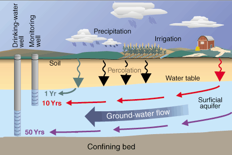
Artesian basin: An artesian basin or aquifer is a confined aquifer containing groundwater under positive pressure. This causes the water level in the well to rise to a point where hydrostatic equilibrium has been reached (balance between pressure on the aquifer and pressure from the aquifer). The diagram below shows an aquifer sandwiched between two aquitards. The aquifer is being recharged from the surface, but it is also been used by humans pumping water out through a well.
Deficit: When evapotranspiration has exceeded precipitation for a long period. During these arid periods deep groundwater will have to be used or artificial stores e.g. reservoir
Recharge: When precipitation exceeds evapotranspiration and groundwater depleted in drier months can be refilled.
Usage: When evapotranspiration is greater than precipitation. During this period groundwater will be used and the level of the water table will start to go down.
Excess: When precipitation exceeds evaporation and groundwater is recharged. When there is excess water the ground will become saturated and the water table will move up.
CAUSES OF GROUNDWATER USAGE
CAUSES OF GROUNDWATER RECHARGE
Evapotranspiration from shallow stores, capillary action will draw moisture up to near the surface
Natural discharge by springs and into lakes, rivers and oceans
Artificial abstraction (removal) for domestic, industrial and agricultural use
Leakage into nearby aquifers
Interbasin transfers
Artificial recharge. Either leakage from irrigation channels and reservoirs or the pumping of water into aquifers.
Infiltration and percolation after precipitation or snow melt
Seepage from river channels, lakes and oceans
Leakage from nearby aquifers
Interbasin transfers
Problems of Depletion
Saltwater intrusion: If aquifers near coastal areas are depleted enough, they may fill back up with saltwater. Once an aquifer has become filled with saltwater, then it is useless for human consumption.
Drought: Periods of drought can be worsened if groundwater has been depleted. Under normal circumstances groundwater can be relied upon in times of drought. However, if groundwater has been managed unsustainably, then there might be no groundwater to rely. This also increases the risk of crop failure, famine and ultimately death of livestock and humans.
Ground subsidence: If too much groundwater is removed, then the ground above the aquifer may sink (subside). This has happened in Mexico City, where its growing population has exploited groundwater unsustainably.
Salinisation: The increased concentration of water, increasing its levels of salinity (saltiness).
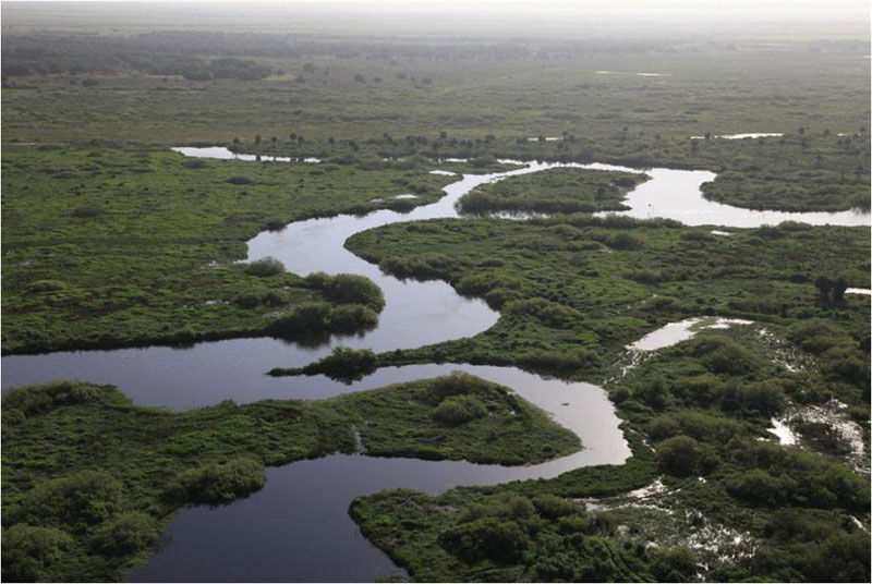
Wetland is an area of land whose soil is saturated with moisture either permanently or seasonally. Such areas may also be covered partially or completely by shallow pools of water. Wetlands include swamps, marshes and bogs. The water found in wetlands can be saltwater, freshwater, or brackish (a mixture of fresh and salt water). The world's largest wetland is the Pantanal which straddles Brazil, Bolivia and Paraguay in South America.
Wetlands now only cover 6% of the earth's surface. This is roughly half the amount of the planet that was covered in wetlands 100 years ago. The most important are:
Bogs (30%): A wetland area that accumulates acidic peat, a deposit of dead plant material. Bogs occur where the water at the ground surface is acidic, either from acidic groundwater, or where water is derived entirely from precipitation Water flowing out of bogs has a characteristic brown color.
Fens (26%): Low land that is covered wholly or partly with water unless artificially drained and that usually has peaty alkaline soil.
Swamps (20%): A swamp is a wetland with some flooding of large areas of land by shallow bodies of water. A swamp generally has a large number of dry-land areas, covered by aquatic vegetation or vegetation that tolerates periodical inundation (being covered by water).
Floodplains (15%): All rivers have floodplains. They are the valley floors that get covered in water when a river exceeds bankfull discharge. However, with an increasing amount of rivers being managed e.g. levees and dams, floodplains are spending less time underwater.
Lakes (2%): Lakes are surface stores that are fed by rivers. Some lakes e.g. Caspian Sea are being drained because of unsustainable use.
Importance of Wetlands
Flood control: Many wetlands are covered in vegetation which can intercept precipitation, absorb rainwater and transpire water. Wetland vegetation can also reduce the velocity of rivers flowing into them or from them and act as natural stores of water. If you remove or drain areas of wetland more pressure is placed upon the main river channel. Coastal and marine wetland areas can also absorb the energy of tropical storms, tsunamis etc.
Groundwater recharge: Wetlands can collect large areas of precipitation and river discharge. As this water is held in storage it will infiltrate and percolate into the ground to recharge groundwater.
Transport Network: Wetland provide many natural waterways that people can move around on easily.
Tourism and Leisure: Some wetlands, like the everglades in Florida or the fens in East England become tourist attractions. They also become popular locations to bird watch, fish and hunt.
Flora and Fauna: Many wetlands are unique habitats that support indigenous aquatic plants and animals. Many wetlands support rare reptilian and amphibian species. Many migratory birds also rest in wetlands flying to and from nesting and breeding grounds.
Fisheries: Wetlands can support large numbers of fish which can support local populations. Wetlands are not normally viable commercial fisheries.
Water purification: The soils, geology and vegetation of wetlands can help clean and purify water.
Storage of organic matter: Wetlands support large areas of organic matter that can hold large stores of methane (greenhouse gas).
Coastal stabilization: Wetlands that occur along the coastline and on river banks have prevent erosion from the sea or by rivers.
Factors Causing Loss and Degradation of Wetlands
Increased demand for agricultural land: As the world population grows there is an increasing demand for food. With the amount of viable agricultural land decreasing, increasingly areas of wetland are being artificially drained to make ways for agricultural land e.g. the draining of the fens in East England.
Population growth: As the world's population grows, it demands more water, more food and more land. The increasing demand for water can mean wetlands are drained of their water or their source of water. This problems is made worse as the world's population develops and uses more water e.g. showers and toilets.
Urbanisation: With the world population growing, there is a greater demand for housing. Increasingly this demand for housing is in urban areas. With urban areas growing more and more wetland areas are being drained or inhabited. Urbanisation on or near wetlands can cause pollution, changes in river flow and river channels and disturbance of wildlife. Land reclamation is the process of reclaiming land from the water.
Sea level rises: Global warming is causing glaciers and ice sheets to melt causing sea levels to rise. These rising sea levels can flood coastal and marine wetland areas. Even if the whole wetland is not flooded, water conditions can be changed from fresh to brackish.
River flow changes: Many rivers have been channelised and straightened, reducing the amount of wetlands. Others have been drained or dams have altered flow. Some have been polluted or redirected. All these natural changes are removing or changing the ecosystems of many wetland areas.
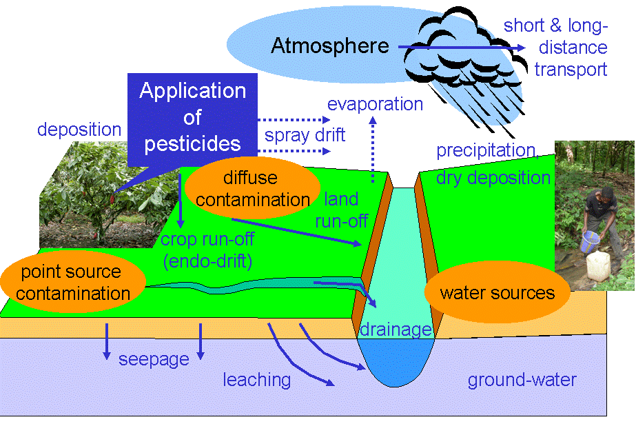
Pollution: Any form of pollution, but particular chemicals and metals can change the delicate ecosystems of wetlands. Process like eutrophication, caused by fertiliser run-off can completely kill whole wetland areas by preventing the wetland oxygenating properly and receiving sunlight.
Infrastructure projects: As populations grow and we become more mobile, there is an increasing demand for new roads, airports, railways. etc. Unfortunately wetlands are often drained or disrupted (bridges, dykes and causeways) to make way for these projects.
Alien species invasion: Many alien species like the cane toad in Australia or the American mink in the UK have been introduced to wetlands and devastated indigenous species. The introduction of any alien, however small can disrupt food webs and ecosystems.
Tropical storms: Although wetlands can be a natural defence against tsunamis and tropical storms, they can also been damaged by them. Freshwater wetlands in particular can be flooded by storms surges associated with tropical storms, changing the salinity of water and damaging vegetation.
The Kissimmee River is found in south central Florida. The source of the Kissimmee river is in East Lake Tohopekaliga and its mouth is in Lake Okeechebee. It has a drainage basin of about 7,800km2 and is approximately 200km long (figures vary depend on when it was measured, before channelisation, after channelisation or after restoration).
The Kissimmee river was home to wetland plants, fish and wading birds. However, the 5km wide floodplain that population living nearby, were regularly effected by its flooding. Because of the flooding the river was widened and channelised from 1962 to 1971. The once meandering river was turned into a 90km long and 10 metre wide drainage canal. Although the scheme was effective at reducing flooding, it had a devastating effect on the wetland ecosystem of the Kissimmee River.
The channelisation was undertaken because of regular flooding. The flooding had been worsened by regular floods hitting the Florida peninsula.
River channelisation: This means artificially widening and lining a river channel. By increasing cross-sectional area and smoothing the bed and the banks, the rivers discharge will flow quicker away from population areas.
River straightening: When meanders are removed from a river and the course is straightened. By removing meanders the river is able to flow faster. The idea is to remove the rivers discharge more quickly from areas with high population densities or land with high value.
external image MAP_SFWMD_GEO.GIF
PROBLEMS CAUSED BY RIVER MANAGEMENT
THE RESTORATION AND ITS BENEFITS
The Kissimmee River floodplain dried up after channelisation. The river no longer exceeded bankfull discharge.
The reduction of the floodplain reduced waterfowl habitat by 90%
Egret, heron and wood stork populations declined by two-thirds.
Catches of largemouth bass (types of fish) reduced after channelisation
Pollution levels from the Kissimmee flowing into Lake Okeechobee after channelisation. The Kissimmee after channelisation accounted for 25% of nitrogen pollution and 20% of phosphorous pollution.
Fishing, bird watching and hunting tourism declined after channelisation
The aim is to restore over 100km2 of river and wetland floodplain by 2015
The restoration project started in 1999
The river is being dechannelised, by refilling the flood canal and reestablishing the old natural course of the river.
Restored sections now flood naturally
The nutrient loads in Lake Okeechobee should be reduced as more is absorbed in the wetland.
Wading birds have returned to the restored sections
Dissolved oxygen levels have doubled in restored sections
Increased revenue from tourism potential of restored river
Reestablishment of natural ecosystem
There are a few possible negative impacts from restoration:
GRAVITY FLOW:This type of irrigation is normally done through the use of drainage ditches and canals. It is called gravity flow, because water is transported under gravity. Gravity flow systems normally flood the whole field. Gravity flow is normally used when flooding rice paddies are adding water to cotton fields (both very thirsty crops).
The technology is relatively simple and can be developed anywhere.
The technology is inexpensive and just involves a lot of manpower.
Effective for areas that need saturating i.e. rice paddies.
A lot of excess water will infiltrate, recharging soil moisture and groundwater stores.
Fields can become watterlogged (saturated).
It creates temporary and artificial surface stores which increase evaporation. Also water is evaporated from the irrigation channels.
The watterlogging of fields and the flow of water can cause the fertile topsoil to be eroded.
Areas of land with no crops may be watered, therefore wasting the water.
Gravity flow can be hard to stop completely, it can only be redirected to other areas.
SPRINKLERS: This type of system normally operates from a central pivot and sprays water over a field. Water is normally pumped through pipes and hoses to the area that is being irrigated (sprayed).
Sprinklers can be turned on and off when necessary, so they respond directly to demand.
Sprinklers can normally be directed only to water areas of vegetation so there is less wastage.
Water spraying through the atmosphere can be evaporated.
You need a central source of water that can be turned on or off.
If the water pressure is low, the sprinklers will not work.
They are expensive to install and may need electricity to pump water.
DRIP SYSTEMS: These are the most precise form of irrigation and add water directly to the stem or trunk of a plant. Water is transported through hoses and pipes and simply drips out of holes in the hose/pipe.
These are the most efficient forms of irrigation. The supply of water can be turned on and off to react to demand. Only the crops that need water receive water.
There is less water lost through evaporation.
They can be very expensive to install, especially over large areas.
They are not suitable for irrigated some crops, like rice.
Again they need a supply of water that can be turned on and off and may need an electricity supply to pump water
POSITIVE IMPACTS OF IRRIGATION
NEGATIVE IMPACTS OF IRRIGATION
Irrigation increases the amount of agricultural land, by making arid areas more productive. Irrigation may increase the number of harvests and the size of the yields.
Irrigation can reduce malnutrition and reduce countries dependency on food imports. It can also provide a valuable source of foreign currency as agricultural exports can be sold.
By increasing the supply of agricultural products, the price of food can be reduced on the global market.
Irrigation can actually increase the water table of the area, because of infiltration. However, it must be remembered that extra water can not be created, so by raising the water table in one area, you must be reducing the amount of water in another area.
Irrigation can increase precipitation. With the increased availability of water, evapotranspiration rates increase. This increases the humidity of the atmosphere and increases the chance of precipitation
Irrigation can reduce the earth's albedo (the reflectivity). This is because sandy surfaces have a higher albedo than dark green surfaces. If you reduce the earth's albedo then more incoming radiation is absorbed by the surface of the earth, furthering global warming. Obviously this change in albedo has to be offset by the increased amount of photosynthesis and also the increase in shaded areas.
If groundwater is used unsustainably, irrigation can cause the water table to fall. In Texas, US, the water table has fallen by up to 50 metres.
Irrigation has been blamed for creating tornadoes in Texas. Tornadoes are circulating columns of air in contact with the ground and cumulonimbus cloud. To develop they need a high moisture content in the atmosphere
Irrigation often leads to an increase in salinisation. This can because of increased evaporation from surface stores (reservoirs) and irrigation channels or water being drawn to the surface and evaporating.
Because irrigation increases the amount of agricultural land, it is also blamed for the increase in the amount of fertilisers used. This in turn can lead to eutrophication of wetlands.