
Competing demands for water
Conflict at local scale - Murray-Darling basin, Australia
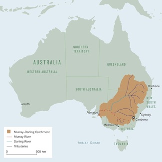
Source: http://www.thegeographeronline.net/freshwater---issues-and-conflicts.html
Although the Murray-Darling is Australia's longest river system, draining a basin the size of France and Spain combined, it no longer carries enough water to carve its own path to the sea. After 10 years of drought, and many more years of overexploitation and pollution, the only hope of restoring the river to health lies in a complete overhaul of how it is managed.
Droughts have long plagued the Murray-Darling and Australia's population continue to grow along with the demand for water in the cities and for the crops that grow in the river basin. By 1994 human activity was consuming 77% of the river's annual flow. Thanks to a combination of of reduced flow and increased run-off from saline soils churned up by agriculture, the water was becoming unhealthily salty, especially in its lower reaches. The tap water in Adelaide was beginning to taste saline.
Australia embarked on a series of reforms that in many ways serve as a model for the management of big, heavily exploited rivers. New South wales, Victoria and South Australia agreed to cap the amount of water they took from the river. they also made plans to reduce salinity and increase "environmental flows". They agreed on the following reforms:
- There would be no more subsides for irrigation.
- Farmers would be responsible for the maintenance of channels and dams.
- For each river and tributary, scientists would calculate the maximum sustainable allocations of water, and states would make sure that extractions did not exceed that figure.
However, many problems remain. Farmers in certain states can still drill wells to suck up groundwater, and tree plantations absorb much of the rainwater that would otherwise find its way to the river. Small dams on farms, which block small streams or trap run-off from rain or flooding, also prevent water from reaching the river.
Source: Nagle, Garrett and Briony Cooke. Geography Course Companion. Print.
Conflicts at the international scale - River Jordan Drainage Basin and the Mountain Aquifer, Jordan, Israel and Palestine

Source: http://cgge.aag.org/WaterResources1e/cs-1/cs-1_print.html
The River Jordan is 251km in length. The source of the River Jordan is in the Anti-Lebanon mountains. It then travels south from Lebanon, along the border of Syria and Israel, before entering the Sea of Galilee (Lake Tiberias). The river then forms the border of Israel and Jordan, followed by the West Bank (Palestine) and Jordan before having its mouth in the Dead Sea. The Dead Sea is unusual because of its high salt content and low elevation. It is about 400 metres below sea level (the lowest place on the surface of the earth).
Three main tributaries join north of the Sea of Galilee to form the River Jordan. They are:
The Hasbani, which rises in south Lebanon, with an average annual flow of 138 million cubic metres,
The Dan River, in Israel, averaging 245 million cubic metres per year, and
The Banias River flowing from the Golan Heights, averaging 121 million cubic metres per year.
The climate around Israel, Jordan, Palestine and Syria is very arid (much of Jordan and Syria is desert). The dry climate and the growing populations of the five countries along the River Jordan would be enough to cause conflict over the use of the River Jordan. However, if you add the political and religious disagreements of the area, conflict over the River Jordan is likely to increase in the future.
West Bank - Mountain Aquifer
Apart from the River Jordan, the mountain aquifer, largely found in Palestinian territory is the main source of water in Israel and the West Bank. The mountain aquifer in the occupied West Bank is largely used by Israel (80%), only leaving 20% for the Palestinians. The Israel's claim that they have the right to use the aquifer, because some of the water flows (groundwater flow or base flow) into Israeli territory. The coastal aquifer shown to the right (in the Gaza Strip - also part of the Palestinian territory), is becoming exhausted and at threat from saltwater intrusion as well as domestic and industrial pollution.
Within the West Bank, you find Palestinians and Israeli's living in illegal settlements. The graph below shows that the level of water consumption among Israeli's and Palestinian's living in the territory is very uneven. On average Israeli's consume nearly 300 liters and Palestinians about 70 liters.

Source: http://greenfieldgeography.wikispaces.com/Conflicts+at+the+local+or+national+scale
No comments:
Post a Comment