Oceans and climate
Energy transfer
The oceanic conveyor belt
The ocean is not a still body of water. There is constant motion in the ocean in the form of a global ocean conveyor belt. This motion is caused by a combination of thermohaline currents (thermo = temperature; haline = salinity) in the deep ocean and wind-driven currents on the surface. Cold, salty water is dense and sinks to the bottom of the ocean while warm water is less dense and remains on the surface.
The ocean conveyor gets its “start” in the Norwegian Sea, where warm water from the Gulf Stream heats the atmosphere in the cold northern latitudes. This loss of heat to the atmosphere makes the water cooler and denser, causing it to sink to the bottom of the ocean. As more warm water is transported north, the cooler water sinks and moves south to make room for the incoming warm water. This cold bottom water flows south of the equator all the way down to Antarctica. Eventually, the cold bottom waters returm to the surface through mixing and wind-driven upwelling, continuing the conveyor belt that encircles the globe.
Source: http://oceanservice.noaa.gov/facts/conveyor.html

Source: http://oceanmotion.org/html/background/ocean-conveyor-belt.htm
Stage 1: Cold, salty, dense water sinks at the Earth's northern polar region and heads south along the western Atlantic basin.

Stage 2: The current is "recharged" as it travels along the coast of Antarctica and picks up more cold, salty, dense water.
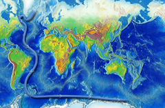
Stage 3: The main current splits into two sections, one traveling northward into the Indian Ocean, while the other heads up into the western Pacific.
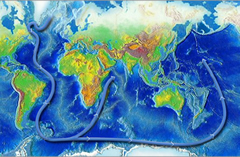
Stage 4: The two branches of the current warm and rise as they travel northward, then loop back around southward and westward.

Stage 5: The now-warmed surface waters continue circulating around the globe. They eventually return to the North Atlantic where the cycle begins again.

Source: http://www.thegeographeronline.net/oceans-and-their-coastal-margins.html
Thermohaline flow
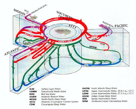
The diagram depicts the Atlantic, Pacific and Indian Oceans essentially as continent-enclosed arms radiating from the central Southern Ocean. Although the diagram is schematic rather than a realistic map, it nonetheless conveys basic information about the global thermohaline circulation, and in greater specificity than the map above. The currents depicted are color-coded: purple for surface currents, red for those at intermediate levels and for Antarctic subsurface water, green for deep currents, and blue for those which hug the ocean bottom (From Siedler, 2001, figure 1.2.7, as taken from Schmitz, 1996).
Source: http://www.killerinourmidst.com/THC.html
The Coriolis effect
Source: http://www.slideshare.net/mswilliams/ocean-currents-powerpoint-2732219
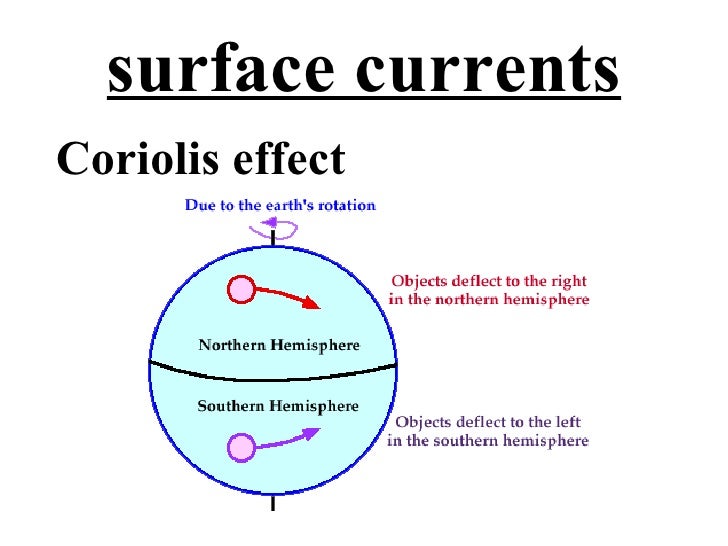
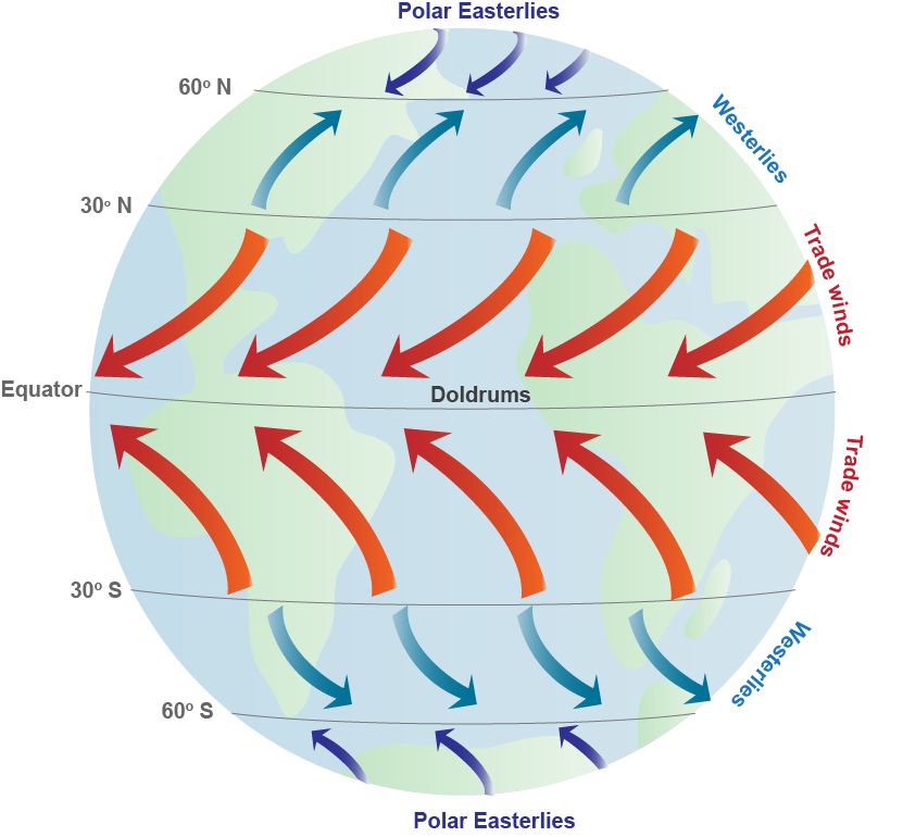
If the Earth did not rotate and remained stationary, the atmosphere would circulate between the poles (high pressure areas) and the equator (a low pressure area) in a simple back-and-forth pattern. But because the Earth rotates, circulating air is deflected. Instead of circulating in a straight pattern, the air deflects toward the right in the Northern Hemisphere and toward the left in the Southern Hemisphere, resulting in curved paths. This deflection is called the Coriolis effect. It is named after the French mathematician Gaspard Gustave de Coriolis (1792-1843), who studied the transfer of energy in rotating systems like waterwheels. (Ross, 1995).
Source: http://www.thegeographeronline.net/oceans-and-their-coastal-margins.html

Source: http://oceanservice.noaa.gov/education/kits/currents/media/supp_cur05a.html
Global winds drag on the water’s surface, causing it to move and build up in the direction that the wind is blowing. And just as the Coriolis effect deflects winds to the right in the Northern Hemisphere and to the left in the Southern Hemisphere, it also results in the deflection of major surface ocean currents to the right in the Northern Hemisphere (in a clockwise spiral) and to the left in the Southern Hemisphere (in a counter-clockwise spiral). These major spirals of ocean-circling currents are called “gyres” and occur north and south of the equator. They do not occur at the equator, where the Coriolis effect is not present (Ross, 1995).
Source: http://www.thegeographeronline.net/oceans-and-their-coastal-margins.html
Source: http://www.teachoceanscience.net/teaching_resources/education_modules/observing_the_ocean/explore_ocean_physics/physical_forces_shaping_ocean_circulation/
Atmosphere-oceanic interactions: El Niño Southern Ocillation (ENSO)
The El Niño-Southern Oscillation (ENSO) is a naturally occurring phenomenon that involves fluctuating ocean temperatures in the equatorial Pacific. The warmer waters essentially slosh, or oscillate, back and forth across the Pacific, much like water in a bath tub. For North America and much of the globe, the phenomenon is known as a dominant force causing variations in regional climate patterns. The pattern generally fluctuates between two states: warmer than normal central and eastern equatorial Pacific SSTs (El Niño) and cooler than normal central and eastern equatorial Pacific SSTs (La Niña).
Often, sea surface temperatures (SSTs) are used to identify this oscillation, but it is important to understand that changes in sub-surface ocean temperatures are the first to respond to an oncoming change in the ENSO phase. For instance, when ENSO is transitioning into a warm phase the sub-surface temperatures begin to warm above average, while a shallow layer of near average temperature remains at the surface. Eventually, the surface ocean temperatures will respond to the warming of the sub-surface temperatures, and a warm phase of the ENSO cycle ensues. The same cycle occurs, only opposite, for the cool phase of ENSO. When temperatures in the ENSO region of the Pacific are near average it is known as ENSO neutral, meaning that the oscillation is neither in a warm nor cool phase. Typically, atmospheric patterns during ENSO neutral are controlled more by other climate patterns (NAO, PNA) that vary on shorter timescales
Source: http://climate.ncsu.edu/climate/patterns/ENSO.html

Source: http://www.thegeographeronline.net/oceans-and-their-coastal-margins.html
El niño
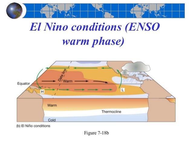
The warm phase of the ENSO cycle features warmer than normal SSTs across the central and eastern equatorial Pacific
along with:
- Weaker low-level atmospheric winds along the equator
- Enhanced convection across the entire equatorial Pacific
- Effects are strongest during northern hemisphere winter due to the fact that ocean temperatures worldwide are at their warmest. This increased ocean warmth enhances convection, which then alters the jet stream such that it becomes more active over parts of the U.S. during El Niño winters. This results in enhanced precipitation across the southern U.S., including NC
- In the southeast, winter temperatures are often cooler than normal
- During hurricane season (June to November), the jet stream is aligned in such a way that the vertical wind shear is increased over the Caribbean and Atlantic. The increased wind shear helps to prevent tropical disturbances from developing into hurricanes
Source: http://climate.ncsu.edu/climate/patterns/ENSO.html
Source: http://www.thegeographeronline.net/oceans-and-their-coastal-margins.html
La Niña
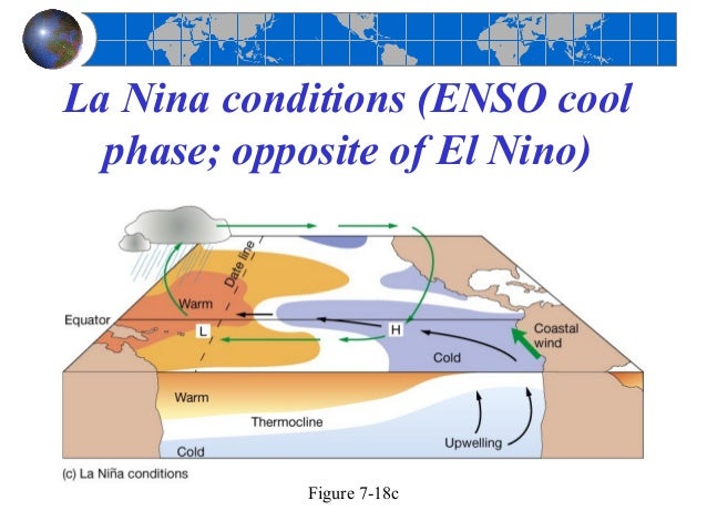
This phase of the ENSO cycle features cooler than normal SSTs across the central and eastern equatorial Pacific along with:
- Stronger low-level atmospheric winds along the equator
- Decreased convection across the entire equatorial Pacific results in a more suppressed southern jet stream. Consequently, the southern U.S., including NC, sees less precipitation
- In the U.S., winter temperatures are often warmer than normal in the southeast, and cooler than normal in the Northwest
- During hurricane season (June to November), upper level winds are much lighter, and therefore more favorable for hurricane development in the Caribbean and Atlantic
Source: http://www.thegeographeronline.net/oceans-and-their-coastal-margins.html
Climatic effects
Tropical cyclones
Most tropical cyclones form on the side of the subtropical ridge closer to the equator, then move poleward past the ridge axis before recurving into the main belt of the Westerlies. Areas west of Japan and Korea tend to experience much fewer September–November tropical cyclone impacts during El Niño and neutral years. During El Niño years, the break in the subtropical ridge tends to lie near 130°E, which would favor the Japanese archipelago.
Within the Atlantic Ocean vertical wind shear is increased, which inhibits tropical cyclone genesis and intensification, by causing the westerly winds in the atmosphere to be stronger. The atmosphere over the Atlantic ocean can also be drier and more stable during El Niño events, which can also inhibit tropical cyclone genesis and intensification. Within the Eastern Pacific basin: El Niño events contribute to decreased easterly vertical wind shear and favours above-normal hurricane activity. However, the impacts of the ENSO state in this region can vary and are strongly influenced by background climate patterns. The Western Pacific basin experiences a change in the location of where tropical cyclones form during El Niño events, without a major change in how many develop each year. As a result of this change Micronesia is more likely to be affected by several tropical cyclones, while China has a decreased risk of being affected by several tropical cyclones. A change in the location of where tropical cyclones form also occurs within the Southern Pacific Ocean between 135°E and 120°W, with tropical cyclones more likely to occur within the Southern Pacific basin than the Australian region. As a result of this change tropical cyclones are 50% less likely to make landfall on Queensland, while the risk of a tropical cyclone is elevated for island nations like Niue, French Polynesia, Tonga, Tuvalu and the Cook Islands.
Remote influence on tropical Atlantic Ocean
A study of climate records has shown that El Niño events in the equatorial Pacific are generally associated with a warm tropical North Atlantic in the following spring and summer. About half of El Niño events persist sufficiently into the spring months for the Western Hemisphere Warm Pool to become unusually large in summer. Occasionally, El Niño's effect on the Atlantic Walker circulation over South America strengthens the easterly trade winds in the western equatorial Atlantic region. As a result, an unusual cooling may occur in the eastern equatorial Atlantic in spring and summer following El Niño peaks in winter. Cases of El Niño-type events in both oceans simultaneously have been linked to severe famines related to the extended failure of monsoon rains.
Antarctica
Many ENSO linkages exist in the high southern latitudes around Antarctica. Specifically, El Niño conditions result in high pressure anomalies over the Amundsen and Bellingshausen Seas, causing reduced sea ice and increased poleward heat fluxes in these sectors, as well as the Ross Sea. The Weddell Sea, conversely, tends to become colder with more sea ice during El Niño. The exact opposite heating and atmospheric pressure anomalies occur during La Niña. This pattern of variability is known as the Antarctic dipole mode, although the Antarctic response to ENSO forcing is not ubiquitous.
Regional impacts
Observations of El Niño events since 1950, show that impacts associated with El Niño events depend on what season it is. However, while certain events and impacts are expected to occur during events, it is not certain or guaranteed that they will occur. The impacts that generally do occur during most El Niño events include below-average rainfall over Indonesia and northern South America, while above average rainfall occurs in southeastern South America, eastern equatorial Africa, and the southern United States.
Australia and the Southern Pacific
During El Niño events, the shift in rainfall away from the Western Pacific, can mean that rainfall across Australia is reduced. Over the southern part of the continent, warmer than average temperatures can be recorded as weather systems are more mobile and fewer blocking areas of high pressure occur. The onset of the Indo-Australian Monsoon in tropical Australia is delayed by two to six weeks, which as a consequence means that rainfall is reduced over the northern tropics. The risk of a significant bushfire season in south-eastern Australia is higher following an El Niño event, especially when it is combined with a positive Indian Ocean Dipole event. During an El Niño event, New Zealand tends to experience stronger or more frequent westerly winds during their summer, which leads to an elevated risk of drier than normal conditions along the east coast. There is more rain than usual though on New Zealand's West Coast, because of the barrier effect of the North Island mountain ranges and the Southern Alps.
Fiji generally experiences drier than normal conditions during an El Niño, which can lead to drought becoming established over the Islands. However, the main impacts on the island nation is felt about a year after the event becomes established. Within the Samoan Islands, below average rainfall and higher than normal temperatures are recorded during El Niño events, which can lead to droughts and forest fires on the islands. Other impacts include a decrease in the sea level, possibility of coral bleaching in the marine environment and an increased risk of a tropical cyclone affecting Samoa.
Africa
In Africa, East Africa — including Kenya, Tanzania, and the White Nile basin — experiences, in the long rains from March to May, wetter-than-normal conditions. Conditions are also drier than normal from December to February in south-central Africa, mainly in Zambia, Zimbabwe, Mozambique, and Botswana.
Asia
As warm water spreads from the west Pacific and the Indian Ocean to the east Pacific, it takes the rain with it, causing extensive drought in the western Pacific and rainfall in the normally dry eastern Pacific. Singapore experienced the driest February in 2014 since records began in 1869, with only 6.3 mm of rain falling in the month and temperatures hitting as high as 35 °C on 26 February. The years 1968 and 2005 had the next driest Februaries, when 8.4 mm of rain fell.
Europe
El Niño's effects on Europe are controversial, complex and difficult to analyse, as it is one of several factors that influence the weather over the continent and other factors can overwhelm the signal.
North America
Over North America, the main temperature and precipitation impacts of El Niño, generally occur in the six months between October and March. In particular the majority of Canada generally has a milder than normal winters and springs, with the exception of eastern Canada where no significant impacts occur. Within the United States, the impacts generally observed during the six-month period include; wetter-than-average conditions along the Gulf Coast between Texas and Florida, while drier conditions are observed in Hawaii, the Ohio Valley, Pacific Northwest and the Rocky Mountains. Over California and the South-Western United States, there is a weak relationship between El Nino and above-average precipitation, as it strongly depends on the strength of the El Niño event amongst other factors.
The synoptic condition for the Tehuantepecer is associated with high-pressure system forming in Sierra Madre of Mexico in the wake of an advancing cold front, which causes winds to accelerate through the Isthmus of Tehuantepec. Tehuantepecers primarily occur during the cold season months for the region in the wake of cold fronts, between October and February, with a summer maximum in July caused by the westward extension of the Azores High. Wind magnitude is greater during El Niño years than during La Niña years, due to the more frequent cold frontal incursions during El Niño winters. Its effects can last from a few hours to six days.
South America
Because El Niño's warm pool feeds thunderstorms above, it creates increased rainfall across the east-central and eastern Pacific Ocean, including several portions of the South American west coast. The effects of El Niño in South America are direct and stronger than in North America. An El Niño is associated with warm and very wet weather months in April–October along the coasts of northern Peru and Ecuador, causing major flooding whenever the event is strong or extreme.The effects during the months of February, March, and April may become critical. Along the west coast of South America, El Niño reduces the upwelling of cold, nutrient-rich water that sustains large fish populations, which in turn sustain abundant sea birds, whose droppings support the fertilizer industry. The reduction in upwelling leads to fish kills off the shore of Peru.
The local fishing industry along the affected coastline can suffer during long-lasting El Niño events. The world's largest fishery collapsed due to overfishing during the 1972 El Niño Peruvian anchoveta reduction. During the 1982–83 event, jack mackerel and anchoveta populations were reduced, scallops increased in warmer water, but hake followed cooler water down the continental slope, while shrimp and sardines moved southward, so some catches decreased while others increased. Horse mackerel have increased in the region during warm events. Shifting locations and types of fish due to changing conditions provide challenges for fishing industries. Peruvian sardines have moved during El Niño events to Chilean areas. Other conditions provide further complications, such as the government of Chile in 1991 creating restrictions on the fishing areas for self-employed fishermen and industrial fleets.
The ENSO variability may contribute to the great success of small, fast-growing species along the Peruvian coast, as periods of low population removes predators in the area. Similar effects benefit migratory birds that travel each spring from predator-rich tropical areas to distant winter-stressed nesting areas.
Southern Brazil and northern Argentina also experience wetter than normal conditions, but mainly during the spring and early summer. Central Chile receives a mild winter with large rainfall, and the Peruvian-Bolivian Altiplano is sometimes exposed to unusual winter snowfall events. Drier and hotter weather occurs in parts of the Amazon River Basin, Colombia, and Central America.
Source: https://en.wikipedia.org/wiki/El_Ni%C3%B1o
Environmental effects
Condition: Effect:
warmer sea temperatures plankton and fish kills in coastal waters
lower sea levels exposure of underwater, fragile coral reefs
higher sea levels salt water intrusion into water supplies
coastal erosion and damage to shoreline and property
flooding/increased rainfall contamination of drinking water systems
flooding of wastewater systems
contamination of recreational sites and estuaries
waterborne illness
droughts crop failure
increase in disease due to lack of water for sanitation and hygiene
blowing dust
pollution of viable water sources
decrease in near-shore coastal water quality
warmer, wetter, more humid weather boom in mosquito population and subsequent increase in malaria and dengue fever
boom in termite population resulting in damage to buildings and homes
Source: http://www.waterandhealth.org/newsletter/new/summer-1998/elnino.html
Economic effects
When El Niño conditions last for many months, extensive ocean warming and the reduction in easterly trade winds limits upwelling of cold nutrient-rich deep water, and its economic effect on local fishing for an international market can be serious.
More generally, El Niño can affect commodity prices and the macroeconomy of different countries. It can constrain the supply of rain-driven agricultural commodities; reduce agricultural output, construction, and services activities; create food-price and generalised inflation; and may trigger social unrest in commodity-dependent poor countries that primarily rely on imported food.A University of Cambridge Working Paper shows that while Australia, Chile, Indonesia, India, Japan, New Zealand and South Africa face a short-lived fall in economic activity in response to an El Niño shock, other countries may actually benefit from an El Niño weather shock (either directly or indirectly through positive spillovers from major trading partners), for instance, Argentina, Canada, Mexico and the United States. Furthermore, most countries experience short-run inflationary pressures following an El Niño shock, while global energy and non-fuel commodity prices increase. The IMF estimates a significant El Niño can boost the GDP of the United States by about 0.5% (due largely to lower heating bills) and reduce the GDP of Indonesia by about 1.0%.
Source: https://en.wikipedia.org/wiki/El_Ni%C3%B1o
Carbon dioxide (CO2)
The ocean dominates the earth's carbon cycle. Half the photosynthesis (primary productivity) on earth takes place in the sunlit layers of the ocean and the ocean absorbs half of all carbon dioxide added to the atmosphere.
The ocean is what we call a carbon sink - actually the largest carbon sink on earth! That means it stores carbon.

Source: http://www.thegeographeronline.net/oceans-and-their-coastal-margins.html

No comments:
Post a Comment