
Urban land use
Residential areas
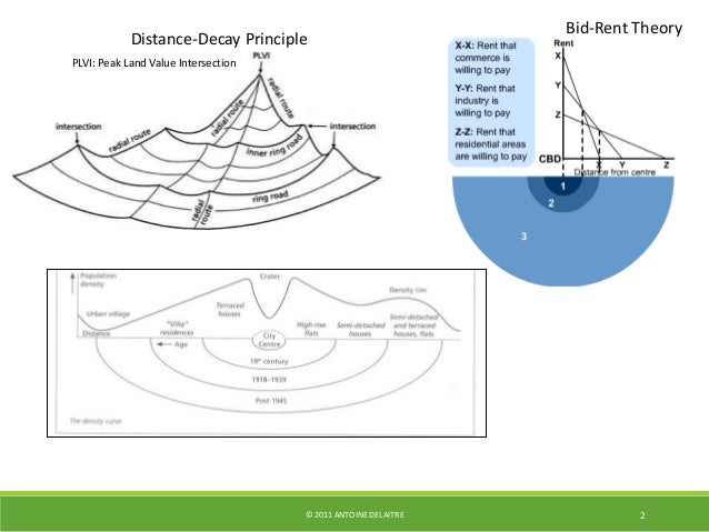
Urban land use in MEDCs
Source: http://www.thegeographeronline.net/urban-environments.html
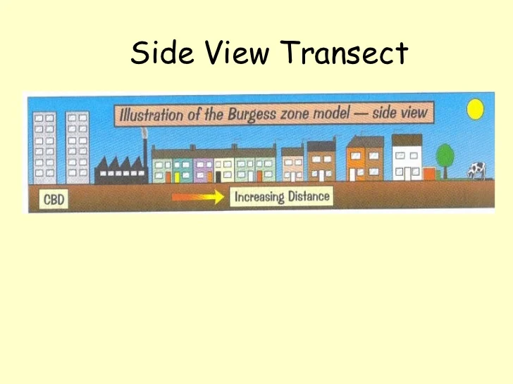
Burgess model
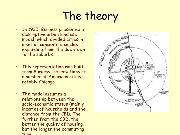
Source: http://www.slideshare.net/cheergalsal/the-burgess-model-481455
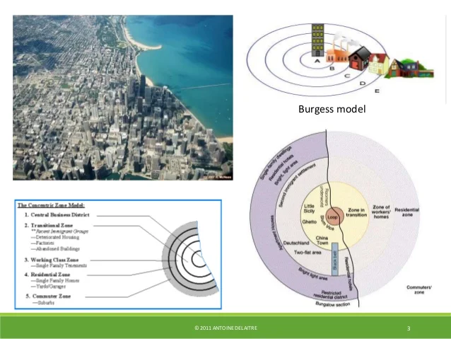
Source: http://www.thegeographeronline.net/urban-environments.html
Source: http://www.slideshare.net/cheergalsal/the-burgess-model-481455
Hoyt model

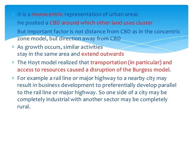
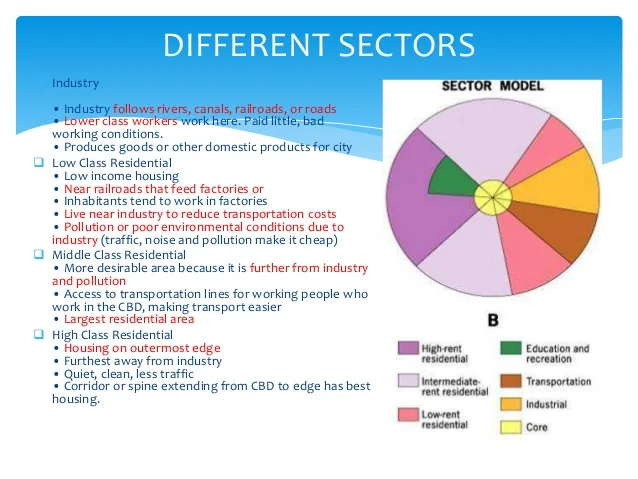
Source: http://www.slideshare.net/SUKHBIRDV/sector-theory
Harris and Ullman multiple nuclei model

Source: http://www.markedbyteachers.com/as-and-a-level/geography/land-use-pattern.html


Source: http://www.slideshare.net/atikulsm/multiple-nuclei-model
Getis, Getis and Fellmann integrated model of a large US city

In reality, most cities in industrialized countries show a land use pattern that is a combination of all three models. Getis, Getis and Fellmann suggest a model of a U.S. city that is probably applicable also to cities in Australia and elsewhere that combines the three earlier theoretical models.
Source: Codrington, Stephen B. Planet Geography. Adelaide: Solid Star Press, 2002. Print.
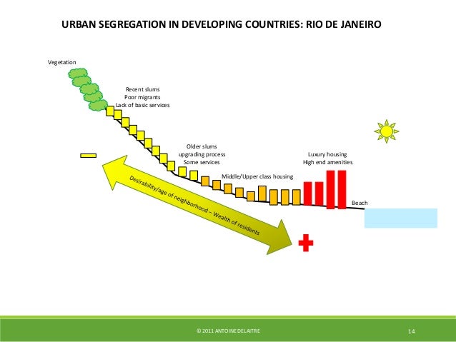
Urban land use in LEDCs
Cities in LEDCs usually develop bit by bit, growing outwards by adding shanty settlements on the outskirts of the city. As time passes, these shanty settlements evolve into permanent buildings and a new 'ring' of shanties develops further out, causing the city to expand horizontally. In this way, cities in LEDCs tend to develop with the wealthy elite living close to the city center, with the people becoming progressively poorer towards the outskirts. Bands of manufacturing industry are generally situated along major lines of communication such as roads and railways.

Any model such as the one represented above is a vast simplification of reality. The simplest models are the easiest to use but they are not very useful for predicting reality. The simplest models are more useful for highlighting broad patterns and processes. On the other hand, as we make models more realistic, they become more complex and more difficult to use. To be effective and useful, therefore, a good model will fall between the two extremes.
With this in mind, we can make the model of the developing world city shown bellow somewhat more realistic without making it too complex.

Source: Codrington, Stephen B. Planet Geography. Adelaide: Solid Star Press, 2002. Print.
| Person | Name | MEDCs or LEDCs | Characteristics | Problems or limitations |
| Burgess | Concentric model | MEDC (Chicago) |
| Specific to one place (Chicago)
One time (1920)
Ignores transportation and communication routes
Flat
No industries
|
| Hoyt | Sector model | MEDC (142 USA cities) |
| Same as Burgess
Before rapid growth suburbs (before cars)
|
| Mann | Mix between Burgess and Hoyt
Urban structure
| MEDC (England) |
| Before Clean Air Act |
| Ullman and Harris | Multiple nuclei model | MEDC (London) |
| Most descriptive and less predictive |
| Getis, Getis, Fellmann | Integrated model | MEDC |
| MEDCs – shopping centers and transportations |
| Cities in Asia, Africa, and South America | LEDC |
| Still fairly simplistic
Ethnic groups separation missing
Does not show change that happens quickly
|
Source: https://manongeo.wordpress.com/category/urban-morphology/
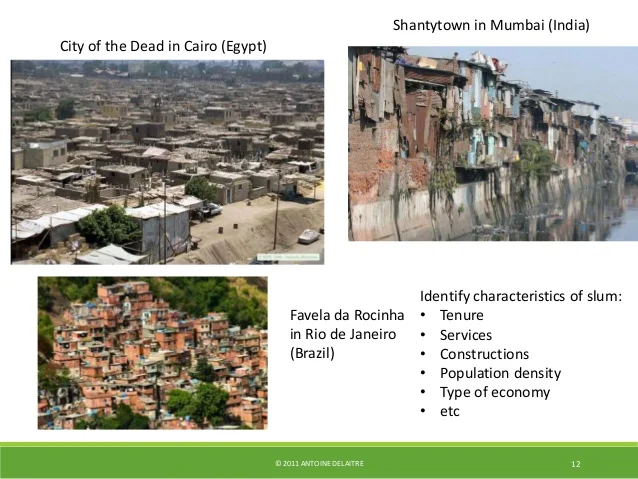
Patterns of urban poverty and deprivation
Slums
A slum, as defined by the United Nations agency UN-HABITAT, is a run-down area of a city characterised by substandard housing and squalor and lacking in tenure security. “Slum” was originally used mainly in the phrase “back slum”, meaning a back room and later “back alley”. The origin of this word is thought to come from the Irish phrase ‘Slomic’ (pron. s’lum ae) meaning ‘exposed vulnerable place’. The Oxford English Dictionary says it may be a “cant” word of Roma (Gypsy) origin. The etymologist Eric Partridge says flatly that it is “of unknown origin”. In short, ‘slum’ means a community of low-class, homeless population.
According to UN Expert Group, slum has been defined as an area that combines various features, including inadequate access to safe water, inadequate access to sanitation and other infrastructure, poor structural quality of housing; overcrowding and insecure residential status.
Characteristics:
The main characteristics of slum population are listed below:
(i) High rate of poverty;
(ii) High incidence of unemployment;
(iii) Huge extent of urban decay;
(iv) Breeding grounds for social problems like crime, drug addiction, alcoholism etc.;
(v) High rates of mental illness and suicide etc.;
(vi) Low level of economic status of its residents;
(vii) Inadequate infrastructural facilities;
(viii) Acute problem of malnutrition
(ix) Lack of drinking water;
(x) Lack of basic healthcare;
(xi) Unsanitary and unary environment;
(xii) Low standard of living or poor quality of life.
Source: http://www.yourarticlelibrary.com/essay/slum-population-meaning-characteristics-and-other-details/42568/
Source: http://www.thegeographeronline.net/urban-environments.html
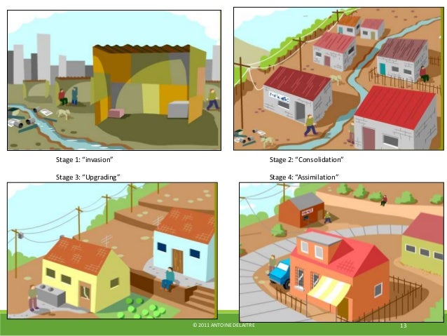
Squatter settlements
A squatter settlement therefore, can be defined as a residential area which has developed without legal claims to the land and/or permission from the concerned authorities to build; as a result of their illegal or semi-legal status, infrastructure and services are usually inadequate. There are essentially three defining characteristics that helps us understand squatter settlement: the Physical, the Social and the legal with the reasons behind them being interrelated.
Physical Characteristics:
A squatter settlement, due to its inherent "non-legal" status, has services and infrastructure below the "adequate" or minimum levels. Such services are both network and social infrastructure, like water supply, sanitation, electricity, roads and drainage; schools, health centres, market places etc. Water supply, for example, to individual households may be absent, or a few public or community stand pipes may have been provided, using either the city networks, or a hand pump itself. Informal networks for the supply of water may also be in place. Similar arrangements may be made for electricity, drainage, toilet facilities etc. with little dependence on public authorities or formal channels.
Social Characteristics:
Most squatter settlement households belong to the lower income group, either working as wage labour or in various informal sector enterprises. On an average, most earn wages at or near the minimum wage level. But household income levels can also be high due to may income earners and part-time jobs. Squatters are predominantly migrants, either rural-urban or urban-urban. But many are also second or third generation squatters.
Legal Characteristics:
The key characteristic that delineates a squatter settlement is its lack of ownership of the land parcel on which they have built their house. These could be vacant government or public land, or marginal land parcels like railway setbacks or "undesirable" marshy land. Thus when the land is not under "productive" use by the owner, it is appropriated by a squatter for building a house. It has to be noted here that in many parts of Asia, a land owner may "rent" out his land for a nominal fee to a family or families, with an informal or quasi-legal arrangement, which is not however valid under law.
In general, there are several attributes that act as generative forces and determine the quality and size of a settlement. Such attributes could be either internal to the settlement or external:
| Internal Attributes | External Attributes |
| Religion/Ethnicity Work place Place of origin Language Length of stay in settlement Investment in housing Construction activity Presence of renters | Land owner Tenure security Municipal/city government policies Length of stay in city |
Source: http://www.gdrc.org/uem/define-squatter.html
Low-cost housing
Urban deprivation can be defined as a standard of living below that of the majority in a particular society that involves hardships and lack of access to resources. Places suffering from urban deprivation often have visible differences in housing and economic opportunities been the rich living alongside poor people. Based off of the previously stated information, this essay will focus on the physical, economic and social indicators that are used to measure deprivation.
- Physical Indicators: quality of housing, levels of pollution or contamination of area, incidence of crime, vandalism, graffiti.
- Social Indicators: reported fear of crime, levels of health and access to healthcare standards of education, proportion of population on subsidized programs like free and reduced school lunch, disability, unemployment and proportion of single parent families.
- Economic Indicators: access to employment, unemployment, levels of income, and percent living in poverty.
Source: http://ibgeostah.blogspot.com.br/2015/11/urban-deprivation-detroit.html
Inner city areas

When and Why did Inner City Areas Grow up?
Developed during the 19 th century – due to rapid expansion of industry (led to the demand for workers). As more moved to the cities – there was a demand for low cost houses for the workers. This resulted in high-density cheap housing (fitting as many houses as possible in a small area. People had to live close to work due to lack of transport.

Typical Characteristics of Inner City Areas
- High Density Housing Mainly terraced (some back to back)
- Built in Long Straight Rows Front doors opening onto the street
- Few Amenities little or no sanitation often built with toilet in Back Yard
- Mainly Ethnic Minorities, students, older people and unemployed (lower income groups)
- Mainly private / rented
Problems in Inner City Areas (since 1950s / 1960s)
1. Industrial Decline (see other notes)
2. High unemployment
3. Abandoned Warehouses – eyesore and led to vandalism
4. High Crime Rates
5. Poor Quality Housing
6. Overcrowding
7. Lack of Open Space
8. Lack of Parking Spaces
9. Atmospheric Pollution (factories / traffic)
10. Lots of heavy traffic (for industry)
Areas of economic activity
Industrial land use


The CBD

Source: https://www.flickr.com/photos/reggiewan/4925600972
The CBD or Central Business District is focal point of a city. It is the commercial, office, retail, and cultural center of the city and usually is the center point for transportation networks.
The History of the CBD
The CBD developed as the market square in ancient cities. On market days, farmers, merchants and consumers would gather in the center of the city to exchange, buy, and sell goods. This ancient market is the forerunner to the CBD.
As cities grew and developed, CBDs became fixed location where retail and commerce took place.
The CBD is typically at or near the oldest part of the city and is often near a major transportation route that provided the site for the city's location, such as a river, railroad, or highway.
Over time, the CBD developed into a center of finance and control or government as well as office space. In the early 1900s, European and American cities had CBDs that featured primarily retail and commercial cores.
In the mid-20th century, the CBD expanded to include office space and commercial businesses while retail took a back seat. The growth of the skyscraper occurred in CBDs, making them more and more dense.
The Modern CBD
By the beginning of the 21st century, the CBD had become a diverse region of the metropolitan area and included residential, retail, commercial, universities, entertainment, government, financial institutions, medical centers, and culture. The experts of the city are often located at workplaces or institutions in the CBD – lawyers, doctors, academics, government officials and bureaucrats, entertainers, directors and financiers.
In recent decades, the combination of gentrification (residential expansion) and development of shopping malls as entertainment centers have given the CBD new life.
Once can now find, in addition to housing, mega-malls, theaters, museums, and stadiums. San Diego's Horton Plaza is an example of redeveloping the downtown as an entertainment and shopping district. Pedestrian malls are also common today in CBDs in an effort to make the CBD a 24 hour a day destination for not only those who work in the CBD but also to bring in people to live and to play in the CBD.
Without entertainment and cultural opportunities, the CBD is often far more populated during the day than at night as relatively few workers live in the CBD and most do commute to their jobs in the CBD.
The Peak Land Value Intersection
The CBD is home to the Peak Land Value Intersection in the city. The Peak Land Value Intersection is the intersection with the most valuable real estate in the city. This intersection is the core of the CBD and thus the core of the metropolitan area. One would not typically find a vacant lot at the Peak Land Value Intersection but instead one would typically find one of the city's tallest and most valuable skyscrapers.
The CBD is often the center of a metropolitan area's transportation system. Public transit as well as highways converge on the CBD, making it a very accessible to those who live throughout the metropolitan area. On the other hand, the convergence of road networks in the CBD often creates overwhelming traffic jams as commuters from the suburbs attempt to converge on the CBD in the morning and return home at the end of the work day.
Source: http://geography.about.com/od/urbaneconomicgeography/a/cbd.htm
The informal sector
Causes and effects of movement of retailing
The Retailing Revolution
Since the 1970s, retailing has moved away from city centres towards out-of-town areas. Several factors have caused this:
- The behaviour of customers, preferring to shop away from congested and crowded town centres
- Retail organisations such as chain stores becoming more powerful
- Planning policies of governments
- The expansion of private transport (cars) to most of the population, so they can travel further to stores
- Development of better transport infrastructure, especially city edge ring roads (examples: the GRA in Rome, the M25 in London, Route 9 (also known as the New Territories Circular Road) in Hong Kong, and Interstate 287 in New York) allowing faster transport around the city than to the centre
- Demand for larger shopping floor areas as product diversity became more important (the range of products available in 2010 was significantly greater than in 1970)
- Mass-production of larger items such as furniture - the increasing consumer culture and lower quality but cheaper products - creating the need for much larger showrooms
The decreasing popularity of town centres
Town centres have become less popular due to:
- Congestion and other traffic problems making it harder to access the CBD
- More expensive public transport as government subsidies have been lowered in many HICs as governments attempt to reduce costs
- Competition from out-of-town shopping centres (see below)
- General urban decay
The increasing popularity of out-of-town centres
These factors led the out-of-town shopping areas to become much more popular. Examples include:
- The MetroCentre, Gateshead, UK
- New Town Plaza, Sha Tin, Hong Kong
- Porta di Roma, Settebagni, Rome
The features of such areas are:
- Built on greenfield land. This reduces cost because the land does not need to be cleared. In general these sites are flat (which allows easy construction), and the land is relatively cheap at the city edge.
- Near high income population. Because they are on the city edge, the 'local' customers are generally those with enough income to support a high standard of living.
- Near transport interchanges e.g. motorway junctions. This increases the threshold population i.e. the number of people who are within a certain journey time from the stores. It also means that deliveries are much more predictable (fewer traffic jams!) and cheaper.
- Large. Centres tend to offer a big number of shops which allows the full range of shopping to be done. This increases convenience and attracts larger numbers of customers.
- Indoor. Shoppers are attracted to the warmth, light and cleanliness of shopping centres.
However, these projects are blamed with taking away from the vitality of the CBD. As shoppers leave the CBD, businesses there suffer a loss of income and close down. The result is a negative multiplier effect, or 'spiral of decline', as fewer shoppers are attracted to the lower quality of shopping experience.
Source: http://geographylaunchpad.weebly.com/the-movement-of-economic-activity-in-urban-areas.html
Causes and effects of movement of service
Service industries have largely remained in the CBD. This is because they rely on direct contact with people. However, office work has also moved.
There are four types of office:
- Head offices
- Government offices (including national and regional/local government)
- Commercial offices e.g. banking
- Service providers e.g. estate agents, lawyers
Demand
Office space has increased due to increasing demand over the second half of the 20th century. The reasons are:
- Mergers of companies require more head office space
- New companies expanding (especially in finance and technology) means more office space is required compared to industrial space
- LIC and MIC development has led to a larger service industry in those countries
Central location
- Offices are frequently still located in the CBD because of several factors:
- Easier contact with other organisations (functional grouping and agglomeration)
- Tradition
- Prestige (it looks good to have a city centre address)
- Proximity to decision makers
- Existing transport infrastructure
- Staff availability
- IT infrastructure is usually better in the CBD compared to outlying areas
Many companies continue to choose CBD loactions for new offices. For example, Google has offices on 8th Avenue in Manhattan, even though they do not need to be located in the central area.
Decentralisation
However, there has been a movement away from these areas. This is due to
- Rising office costs in the CBD
- Difficulty of expansion in a cramped CBD location
- Congestion leading to longer journey times
- Difficulty of finding parking spaces
- High cost of parking in CBD
- Higher staff costs due to competition for staff
An example of a company that has moved several times is the rental car company Hertz. They moved from Manhattan to New Jersey in 1988, and in 2013 announced that due to a merger with another company they would move their HQ to Florida.
Source: http://geographylaunchpad.weebly.com/the-movement-of-economic-activity-in-urban-areas.html
Causes and effects of movement in manufacturing
Manufacturing movement has largely moved entirely out of urban areas and now takes place in specially constructed areas. This deindustrialisation has been caused by:
- Movement of industry to foreign locations, especially those in Newly Industrialised Countries
- Larger and more complext machinery needing greater space
- New industries creating the need for expansion of industrial areas
The result has been decentralisation. This is a movement:
- Firstly from the city centre to the suburbs
- Then from the suburbs to the very city edge
- From the city edge to out-of-town locations, especially those with bulk transport capabilities such as coastal locations and motorway junctions
It is notable that at each point, greenfield sites are generally preferred. An example is the British motor industry. The following details are sourced from Geofile 532 'Changing Locations in the British Motor Industry' by Jeremy Boot (January 2007, pub. Nelson Thornes). The UK car industry has been in terminal decline for some time. There are now no 'home owned' car manufacturing companies operating at a mass scale. However, in 2005 over 1.1 million cars were exported from the UK. This is mostly due to the investment in British production by overseas car manufacturers who are attracted by the position of the UK within the EU. However, they open their factories at sites such as Burnaston (in the centre of the country) away from urban areas because of the lack of land and the relatively small number of employees that are required by modern industry. The Toyota factory at Burnaston employs only 3900 people (in 2004) and is located around 11km from the nearest small city of Derby.
Source: http://geographylaunchpad.weebly.com/the-movement-of-economic-activity-in-urban-areas.html
No comments:
Post a Comment