
Distribution and morphology of oceans and variations in oceanic waters
Distribution of oceans and ocean currents

Source: http://www.mapsofworld.com/world-ocean-map.htm

Poleward-moving currents are warm, and equatorward-moving currents are cold. Surface ocean currents are driven by global winds and play an important role in redistributing heat around the globe.
Source: http://www.geo.hunter.cuny.edu/tbw/wc.notes/3.temperature/ocean_currents.htm

Source: http://www.ces.fau.edu/nasa/module-3/why-does-temperature-vary/ocean-currents.php
Morphology of oceans

Source: http://www.slideshare.net/stevenheath148/plates-36189164

Source: http://www.thegeographeronline.net/oceans-and-their-coastal-margins.html
Submarine volcanoes
Plate boundaries

Hot spot volcanism

Source: http://volcano.oregonstate.edu/book/export/html/138

Source: http://www.geo.cornell.edu/hawaii/220/PRI/PRI_PT_hotspot.html
Submarine volcanoes at convergent plate boundaries

Source: http://volcano.oregonstate.edu/book/export/html/138
Metis Shoal, a submarine volcano near the Tonga Islands

Source: http://volcano.oregonstate.edu/submarine-volcanoes-convergent-plate-boundaries
Submarine volcanoes at divergent plate boundaries

Source: http://www.buzzle.com/articles/underwater-volcanoes-how-are-underwater-volcanoes-formed.html
Mata Fitu submarine volcano, in the submarine ring of fire

Source: http://oceanexplorer.noaa.gov/facts/volcanoes.html
Trenches

Source: http://oceanwonders.tagmintz.com/trenches.html
Ocean trenches are long, narrow depressions on the seafloor. These chasms are the deepest parts of the ocean—and some of the deepest natural spots on Earth. Ocean trenches are found in every ocean basin on the planet, although the deepest ocean trenches ring the Pacific as part of the so-called “Ring of Fire” that also includes active volcanoes and earthquake zones.
Ocean trenches are a result of tectonic activity, which describes the movement of the Earth’s lithosphere. In particular, ocean trenches are a feature of convergent plate boundaries, where two or more tectonic plates meet. At many convergent plate boundaries, dense lithosphere melts or slides beneath less-dense lithosphere in a process called subduction, creating a trench.
Ocean trenches occupy the deepest layer of the ocean, the hadalpelagic zone. The intense pressure, lack of sunlight, and frigid temperatures of the hadalpelagic zone make ocean trenches some of the most unique habitats on Earth.
Source: http://nationalgeographic.org/encyclopedia/ocean-trench/

Source: http://www.extremescience.com/deep-ocean-trenches.htm

Source: https://www.haikudeck.com/plate-tectonics-inspiration-presentation-zFuF6ePl1s
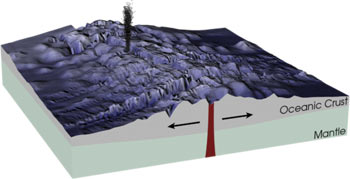
Mid-ocean ridges
A mid-ocean ridge or mid-oceanic ridge is an underwater mountain range, formed by plate tectonics.
This uplifting of the ocean floor occurs when convection currents rise in the mantle beneath the oceanic crust and create magma where two tectonic plates meet at a divergent boundary.
The mid-ocean ridges of the world are connected and form a single global mid-oceanic ridge system that is part of every ocean, making the mid-oceanic ridge system the longest mountain range in the world, with a total length of about 60,000 km.
Source: https://www.sciencedaily.com/terms/mid-ocean_ridge.htm
Source: https://www.quora.com/What-is-an-example-of-a-mid-ocean-ridge
Source: https://en.wikipedia.org/wiki/Mid-ocean_ridge
Transform faults
Midocean ridges are not continuous features. Midocean ridge spreading centers (MOR on the map below) are offset by numerous transform faults. MORs are, of course, divergent plate boundaries where two plates are spreading apart and new crust is forming by igneous intrusion and extrustion. The transform faults are not divergent boundaries. See the sense of relative motion across the transform faults on the map below. The fracture zones are not plate boundaries. The crust on both sides of a fracture zone are part of the same plate and moving in the same direction (see below).

Fracture zones exist as bathymetric features extending many hundreds of kilometers from the midocean ridge. Because of the offset of the midocean ridge spreading centers, the crust on one side of a fracture zone will be older and therefore colder, more contracted, and deeper than the crust on the other side. The boundary between them is often a deep canyon. These are places where deeper levels of the oceanic crust are exposed.

Source: http://www.columbia.edu/~vjd1/MOR_transforms.htm
Rift valleys

Source: http://nationalgeographic.org/encyclopedia/rift-valley/
A rift valley is a lowland region that forms where Earth’s tectonic plates move apart, or rift. Rift valleys are found both on land and at the bottom of the ocean, where they are created by the process of seafloor spreading. Rift valleys differ from river valleys and glacial valleys in that they are created by tectonic activity and not the process of erosion.
Many of Earth’s deepest rift valleys are found underwater, dividing long mountain ranges called mid-ocean ridges. As tectonic plates move away from one another at mid-ocean ridges, molten rock from the mantle may well up and harden as it contacts the frigid sea, forming new oceanic crust at the bottom of the rift valley.
In the northern Mid-Atlantic Ridge, the North American plate and the Eurasian plate are splitting apart at a rate of about 2.5 centimeters (1 inch) per year. Over millions of years, the Mid-Atlantic Ridge has formed rift valleys as wide as 15 kilometers (9 miles).
In the Pacific Ocean, the East Pacific Rise has created rift valleys where the Pacific plate is separating from the North American plate, Cocos plate, Nazca plate, and Antarctic plate. Like many underwater rift valleys, the East Pacific Rise is dotted with hydrothermal vents. Geologic activity beneath the underwater rift valley creates these vents, which spew super-heated water and vent fluids into the ocean.
Source: http://nationalgeographic.org/encyclopedia/rift-valley/


Source: http://www.thegeographeronline.net/oceans-and-their-coastal-margins.html

Source: https://manoa.hawaii.edu/exploringourfluidearth/physical/density-effects/ocean-temperature-profiles/compare-contrast-connect-vertical-profiles-ocean
Thermocline definition: the zone of rapid temperature change in a vertical body of water. In the oceans the boundary usually occurs between 200m and 800m. Approx. 90% of ocean water is found below the thermocline. Generally the surface waters do not mix with the deeper layers.
Source: http://slideplayer.com/slide/7972788/
Oceanic water temperature
Average temperature: Below 1000m there is a uniform average of 2°C
Source: http://www.thegeographeronline.net/oceans-and-their-coastal-margins.html
Source: https://wattsupwiththat.com/2015/02/18/tao-and-tao-again/
Ocean temperature related to depth - Thermocline
Source: http://www.thegeographeronline.net/oceans-and-their-coastal-margins.html
Source: https://manoa.hawaii.edu/exploringourfluidearth/physical/density-effects/ocean-temperature-profiles/compare-contrast-connect-vertical-profiles-ocean
Thermocline definition: the zone of rapid temperature change in a vertical body of water. In the oceans the boundary usually occurs between 200m and 800m. Approx. 90% of ocean water is found below the thermocline. Generally the surface waters do not mix with the deeper layers.
Source: http://slideplayer.com/slide/7972788/
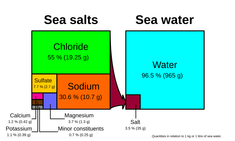
Oceanic water salinity
Average salinity: 35 parts per thousand (ppt)
Source: http://www.thegeographeronline.net/oceans-and-their-coastal-margins.html

Source: https://beta.sciencelearn.org.nz/resources/686-ocean-salinity
Source: https://en.wikipedia.org/wiki/Seawater#/media/File:Sea_salt-e-dp_hg.svg

Source: http://aquarius.umaine.edu/cgi/ed_temperature.htm

Source: http://www.ric.edu/faculty/PSCI103/Seawater/Seawater_notes.htm
How does ocean water salinity change with depth? Halocline - the zone of rapid salinity change in a vertical body of water. In the oceans the boundary usually occurs between 200m and 800m which is in a similar region to the thermocline.

Source: http://slideplayer.com/slide/7972788/
No comments:
Post a Comment