
Coastal margins
Physical characteristics
Tides
The regular rise and fall of the ocean’s waters are known as tides. Along coasts, the water slowly rises up over the shore and then slowly falls back again. When the water has risen to its highest level, covering much of the shore, it is at high tide. When the water falls to its lowest level, it is at low tide. Some lakes and rivers can also have tides.
Causes of Tides
Forces that contribute to tides are called tidal constituents. The Earth’s rotation is a tidal constituent. The major tidal constituent is the moon’s gravitational pull on the Earth. The closer objects are, the greater the gravitational force is between them. Although the sun and moon both exert gravitational force on the Earth, the moon’s pull is stronger because the moon is much closer to the Earth than the sun is.
The moon’s ability to raise tides on the Earth is an example of a tidal force. The moon exerts a tidal force on the whole planet. This has little effect on Earth’s land surfaces, because they are less flexible. Land surfaces do move, however, up to 55 centimeters (22 inches) a day. These movements are called terrestrial tides. Terrestrial tides can change an object’s precise location. Terrestrial tides are important for radio astronomy and calculating coordinates on a global positioning system (GPS). Volcanologists study terrestrial tides because this movement in the Earth’s crust can sometimes trigger a volcanic eruption.
The moon’s tidal force has a much greater effect on the surface of the ocean, of course. Water is liquid and can respond to gravity more dramatically.
Source: http://nationalgeographic.org/encyclopedia/tide/

The relative strength of the attraction of different points on the Earth towards the Moon. The longer the arrow, the stronger the attractive force.

The tidal bulge that forms as a result of the Moon when the attraction of the Earth is taken into account. The (exaggerated) blue outline shows where high and low tides would appear.

A spring tide, produced when the Sun, Earth and Moon are aligned. The blue halo shows the exaggerated tidal bulge. Please note we don’t actually have two Moons, this diagram is showing the possible positions of the Moon.

A neap tide, produced when the Sun and the Moon are at 90° to each other. The blue halo shows the exaggerated tidal bulge that is produced.
Source: https://geographyas.info/coasts/tides/
Waves


Source: https://www.geography-fieldwork.org/coast/coastal-processes.aspx
![[image - wave]](http://www.geography.learnontheinternet.co.uk/images/coast/waves.gif)
![[image - constructive waves]](http://www.geography.learnontheinternet.co.uk/images/coast/constructivewaves.gif)
![[image - destructive waves]](http://www.geography.learnontheinternet.co.uk/images/coast/destructivewaves.gif)
Source: http://www.geography.learnontheinternet.co.uk/topics/waves.html#wave
Littoral drift
Littoral transport is the term used for the transport of non-cohesive sediments, i.e. mainly sand, along the foreshore and the shoreface due to the action of the breaking waves and the longshore current. The littoral transport is also called the longshore transport or the littoral transport.
Source: http://www.coastalwiki.org/wiki/Littoral_drift

Source: https://www.geocaching.com/geocache/GC5XYWH_bray-pebble-beach?guid=abeb7ae4-bcd4-49b1-aa3b-062483f85de5
Source: http://www.bbc.co.uk/education/guides/z3ndmp3/revision/5
Wind action
Wind or "air in motion" occurs in many different meteorological conditions. Air moves due to variations in temperature and pressure. Local wind is generated by differential temperatures between sea and land or mountains and valleys while global wind is triggered by difference in incoming solar radiation and the rotation of the Earth.
Erosion, transport and deposition processes might happen through wind motion, therefore wind plays an important role in landscape alteration. One emblematic example of land form shaped by wind would be mobile (yellow) sand dunes but deflation and abrasion also shape rock formations like in the image below.

Source: http://biocircuits.ucsd.edu/outreach/?p=714
Lithology
Lithology refers to the physical properties of a rock such as its resistance to erosion. The lithology of a coastline affects how quickly it’s eroded. Hard rocks (e.g., Gabbro) are resistant to weathering & erosion so a coastline made of granite (e.g., Land’s End) will change slowly. Soft rocks (e.g., Limestone) are more susceptible to weathering & erosion so a coastline made of chalk (e.g., Dorset) will change relatively quickly.
If you looked down on a coastline from above and saw the geology of the area, you’d be able to see that the rock type changes as you approach the coastline and that the different rocks are arranged in bands. The angle these bands make with the coastline makes it either a concordant or discordant coastline.
Source: https://geographyas.info/coasts/coastal-erosion/
A coastline with rocks that run parallel to the coast is called a concordant or "Pacific" coastline. One that has rocks running at right angles to the coast is called a discordant or "Atlantic" coastline.

Source: http://www.s-cool.co.uk/gcse/geography/coasts/revise-it/coastal-erosion-features
Coastal processes
Coastal erosion
Erosion is the wearing away of the land by the sea. This often involves destructive waves wearing away the coast. There are five main processes which cause coastal erosion. These are corrasion, abrasion, hydraulic action, attrition and corrosion/solution.
- Corrasion is when waves pick up beach material (e.g. pebbles) and hurl them at the base of a cliff.
- Abrasion occurs as breaking waves which contain sand and larger fragments erode the shoreline or headland. It is commonly known as the sand paper effect.
- When waves hit the base of a cliff air is compressed into cracks. When the wave retreats the air rushes out of the gap. Often this causes cliff material to break away. This process is known as hydraulic action.
- Attrition is when waves cause rocks and pebbles to bump into each other and break up.
- Corrosion/solution is when certain types of cliff erode as a result of weak acids in the sea.
Source: http://www.geography.learnontheinternet.co.uk/topics/whatiscoastalerosion.html

Source: http://www.geographypods.com/3-coasts.html
Coastal transportation
Transportation is the movement of material in the sea and along the coast by waves. The movement of material along the coast is called longshore drift (as seen above).
Although longshore drift is the main process of transportation the material moves in four different ways. These are:
- Traction - large material is rolled along the sea floor.
- Saltation - beach material is bounced along the sea floor.
- Suspension - beach material is suspended and carried by the waves.
- Solution - material is disolved and carried by the water.
Source: http://www.geography.learnontheinternet.co.uk/topics/whatiscoastaltransportation.html
Coastal deposition
Deposition is when material that is being transported is dropped by constructive waves. It happens because waves have less energy.
Deposition happens when the swash is stronger than the backwash and is associated with constructive waves.
Deposition is likely to occur when:
- waves enter an area of shallow water.
- waves enter a sheltered area, eg a cove or bay.
- there is little wind.
- there is a good supply of material.
Deposition creates a range of landforms (below).
Source: http://www.geography.learnontheinternet.co.uk/topics/whatiscoastaldeposition.html
Subaerial processes
Sub-aerial process are land based processes which alter the shape of the coastline. These are a combination of weathering and mass movement.
Weathering
Mechanical (physical) weathering
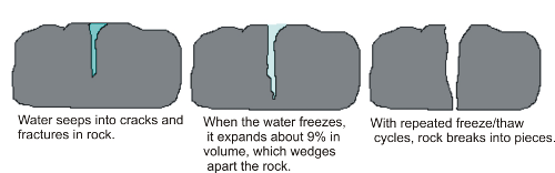
Mechanical or physical weathering is the fracture and breakdown of rocks into fragments. Along the coast it may be caused by frost shattering (freeze-thaw), salt crystallisation, wetting and drying, or even biologically.
Freeze-thaw occurs when water gets into cracks in rocks and freezes. This then expands by around 10%. The repeated freeze thaw action puts pressure on the rocks until they eventually crack and break the rock. Freeze-thaw usually occurs when the temperature oscillates around freezing point. The shattered angular fragments of rock accumulate around the base of the cliff as scree (talus). As coastal climates tend to be milder this process is only really effective during very cold winters.
Source: http://www.alevelgeography.com/sub-aerial-processes/
Source: http://geographyclassroom2014.weebly.com/weathering.html

Source: http://squishyorange.wix.com/welcomtoalaska#!__freeze-thaw
Salt crystallisation happens when salt crystals are deposited in cracks and over time the salt accumulates and applies pressure to the crack (similar to freeze-thaw weathering).
Source: http://www.alevelgeography.com/sub-aerial-processes/

Source: http://www.slideshare.net/tcooper66/weathering-erosion-and-soil-presentation

Source: http://www.slideshare.net/Ammadkhan69/weathering-and-erosion-7591403
Wetting and drying is common along coastlines. Clay rich rocks are prone to expand when they are wet and contract when they dry. This results in cracks which are vulnerable to both freeze-thaw and salt crystallisation.
Source: http://www.alevelgeography.com/sub-aerial-processes/

Source: http://slideplayer.com/slide/7450345/
Biological weathering is mechanical when there is a physical effect. An example of this is when growing plant roots widen cracks as does the leverage created by bushes and trees swaying in strong winds. Burrowing animals and nesting birds excavate material in partially weathered and eroded cliffs.
Source: http://www.alevelgeography.com/sub-aerial-processes/

Source: http://www.slideshare.net/srackley/weathering-388228
Chemical weathering involves decomposition of rocks (literally, changing the minerals). Chemical weathering occurs as a result of a weak chemical reaction between water and rock. eg. with limestone. Rainwater mixed with carbon dioxide in the atmosphere forms Carbonic acid. This then reacts with calcium carbonate in limestone to form calcium bicarbonate. Bicarbonate is soluble in water and the limestone gets weathered when carbonation occurs.
The role of weathering is to weaken cliffs. This weakening speeds up the rates of erosion.
Source: http://www.alevelgeography.com/sub-aerial-processes/

Chemical Weathering such as the one in this picture is caused by long period of time of exposure of different chemicals that break down the rock.
Source: https://frankiefiles.wikispaces.com/Mechanical+and+Chemical+Weathering
Mass movement

Source: http://sageography.myschoolstuff.co.za/wiki/grade-11-caps/grade-11-caps-geomorphology/mass-movements-and-human-responses/
Mass movement is the movement of material downslope as the result of gravity. This can be a slow process in the case of soil creep or fast in the case of rockfalls. Water commonly acts as a lubricant in mass movement.
Soil creep is a slow but continuous process. It typically occurs on most slopes over 5 degrees. Soil creep rarely exceeds speeds of 1cm per year. Creep occurs as the result of repeated expansion and contraction of material. Cycles of freeze thaw heave particles up on freezing and allow them to fall further down slope when the ice melts. Alternating hydration and dehydration have the same effect.
Source: http://www.alevelgeography.com/sub-aerial-processes/


Source: http://sageography.myschoolstuff.co.za/wiki/grade-11-caps/grade-11-caps-geomorphology/mass-movements-and-human-responses/
Earth flows tend to be faster than slow creep but less sporadic. Earthflows have a characteristic “hourglass” shape. The slope material liquefies and runs out, forming a bowl or depression at the head. The flow itself is elongate and usually occurs in fine-grained materials or clay-bearing rocks on moderate slopes and under saturated conditions. However, dry flows of granular material are also possible.
Source: http://www.alevelgeography.com/sub-aerial-processes/

Source: http://sageography.myschoolstuff.co.za/wiki/grade-11-caps/grade-11-caps-geomorphology/mass-movements-and-human-responses/

Source: http://geology.about.com/od/naturalhazardsclimate/ig/Landslides/slide-eflow.htm
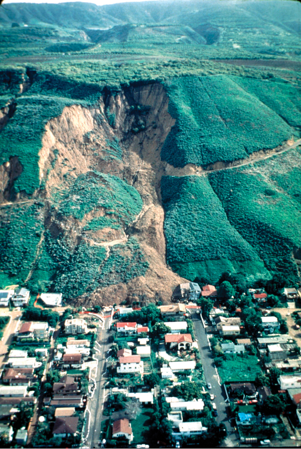
Land Slide is the downslope movement of a large block of material that moves as a coherent mass. This means it retains its internal structure until hitting the base of the slope and fracturing into smaller pieces. It is more common over wet periods, on steep slopes and often occurs on coastlines.
Source: http://www.alevelgeography.com/sub-aerial-processes/
Source: http://pubs.usgs.gov/fs/2004/3072/images/La-ConchitaLG.jpg
Mudflow is an earthflow consisting of material that is wet enough to flow rapidly and that contains at least 50 percent sand, silt, and clay-sized particles. In some instances, for example in many newspaper reports, mudflows and debris flows are commonly referred to as “mudslides.”
Source: http://www.alevelgeography.com/sub-aerial-processes/

Source: http://sageography.myschoolstuff.co.za/wiki/grade-11-caps/grade-11-caps-geomorphology/mass-movements-and-human-responses/
Slumps are one of the most common types of mass movement along the coast are. Slumps happen because of a number of factors. Firstly, marine processes erode and undermine the base of the cliff. Rainwater infiltrates the cliff through unconsolidated, porous material (e.g. boulder clay). This then creates a slip plane. The weight of the saturated clay causes the material to slump along the slip plane.
Source: http://www.alevelgeography.com/sub-aerial-processes/

Source: http://sageography.myschoolstuff.co.za/wiki/grade-11-caps/grade-11-caps-geomorphology/mass-movements-and-human-responses/
Rockfalls are usually associated with near vertical slopes. Only more resistant rock can sustain these angles on the coast. They are most commonly triggered by undercutting in the inter-tidal zone or freeze-thaw weathering.
Run-off
Run-off has the ability to move fine material downslope, particularly where overland flow occurs as a thin, continuous layer (sheet flow) and washes silt and clay sized particles.
Source: http://www.alevelgeography.com/sub-aerial-processes/

Source: https://web.csulb.edu/depts/geology/facultypages/bperry/Mass%20Wasting/Types_of_Mass_Wasting.htm

Source: https://en.wikipedia.org/wiki/Rockfall
Landforms
Erosional landforms
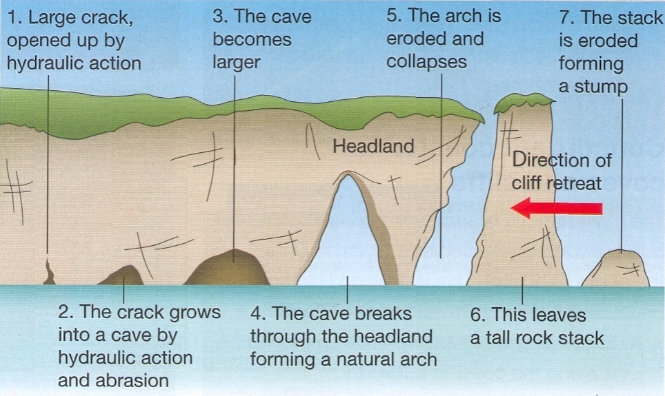
Bays and headlands
Headlands form along coastlines in which bands of soft and hard rock outcrop at right angles to the coastline (see image below). Due to the different nature of the rock erosion occurs at different rates. Less resistant rock (e.g. boulder clay) erodes more rapidly than less resistant rock (e.g. chalk).


Source: http://www.geography.learnontheinternet.co.uk/topics/coasts_erosional_landforms.html
Erosion of headlands
Source: http://thebritishgeographer.weebly.com/coasts-of-erosion-and-coasts-of-deposition.html
Cliff recession

Source: https://ih-igcse-geography.wikispaces.com/2.2.+Coastal+features
Depositional landforms
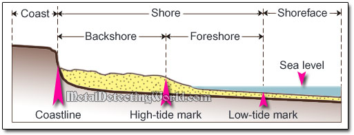
Beaches
The beach is the area between the lowest spring tide level and the point reached by the storm waves in the highest tides. Every beach is different but they are usually made up of material deposited on a wave-cut platform.
Source: http://www.geography.learnontheinternet.co.uk/topics/deposition.html
Source: http://www.metaldetectingworld.com/beach_hunting_p8.shtml
Spit
Longshore drift moves material along a coastline. Where there is an obstruction or the power of the waves is reduced the material is deposited. Where rivers or estuaries meet the sea deposition often occurs. The sediment which is deposited usually builds up over the years to form a long ridge of material (usually sand or shingle). Such a ridge is called a spit.
Source: http://www.geography.learnontheinternet.co.uk/topics/deposition.html
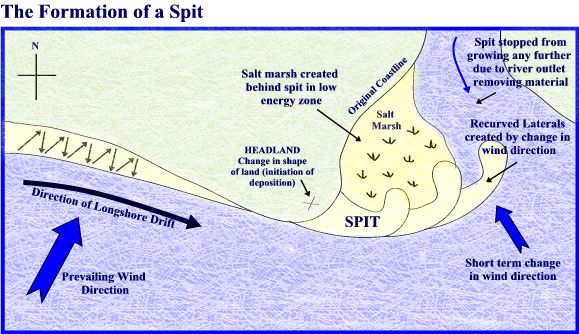
Source: http://thebritishgeographer.weebly.com/coasts-of-erosion-and-coasts-of-deposition.html
Sand Dunes
Sand dunes are small ridges or hills of sand found at the top of a beach, above the usual maximum reach of the waves. They form from wind blown sand that is initially deposited against an obstruction such as a bush, driftwood or rock. As more sand particles are deposited the dunes grow in size, forming rows at right angles to the prevailing wind direction. If vegetation, such as Marram Grass and Sand Couch, begins to grow on the dune its roots will help to bind the sand together and stabilise the dunes.
Sand dunes can be important ecosystems supporting unique plant life and a healthy population of small animals and insects. They are very vulnerable to erosion by natural processes and by human activity. It is common to see vulnerable sections of dunes fenced off to prevent public access, or for paths to be laid to prevent people from eroding the dunes.
Source: http://www.geography-site.co.uk/pages/physical/coastal/dunes.html

Sand dune characteristics:
Embryo dune: The first part of the dune to develop. Stabilisation occurs via marram and lyme grass, which act as traps for sand. Conditions are dry and plants adapt to this via long roots, or thorny leaves to reduce evapotranspiration.
Yellow dune: Colour is due to a lack of humus, but with distance inland they become increasingly grey due to greater amounts of humus. Heights can reach 5m and plants include sand sedge, sea holly, and red fescue.
Fixed grey dunes: Limited growth due to distance from beach. Far more stable as shown by existence of thistle, evening primrose, bracken, bramble and heather.
Dune slacks: Depressions between dune ridges, which will be damp in summer and water-filled in winter. Species include water mint, rushes, and weeping-willow.
Blow outs: Often evidence of over use by humans. Large 'holes' that appear in the dunes.
Advancing and retreating coasts

Source: http://geographymonkey.com/5-coastal-margins.html
Emergent (advancing) Coastlines: found where coasts are growing as a consequence of sediment being deposited along the coast and/or the infill of coastal marshes. May also arise from negative change is sea level. (sea level fall or uplift of land)Result in features such as: raised beaches, wave cut platforms, sea caves above ocean level.
Retreating (Submergent) Coastlines: coasts along which the dominant process is erosional, coastlines moving inland. Caused by a positive change in sea level (sea levels rise or a fall in land level). Features: Rias, Dalmatian Coastlines, drowned glaciated valleys/fjords.
Source: https://quizlet.com/130521329/15-oceans-advancing-and-retreating-coasts-flash-cards/
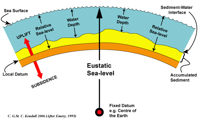
Eustatic Changes
Eustatic change is when the sea level changes due to an alteration in the volume of water in the oceans or, alternatively, a change in the shape of an ocean basin and hence a change in the amount of water the sea can hold. Eustatic change is always a global effect.
During and after an ice age, eustatic change takes place. At the beginning of an ice age, the temperature falls and water is frozen and stored in glaciers inland, suspending the hydrological cycle. This results in water being taken out of the sea but not being put back in leading to an overall fall in sea level. Conversely, as an ice age ends, the temperature begins to rise and so the water stored in the glaciers will reenter the hydrological cycle and the sea will be replenished, increasing the sea levels.
Increases in temperature outside of an ice age will also effect the sea level since an increasing temperature will cause the ice sheets to melt, putting more water in the sea.
The shape of the ocean basins can change due to tectonic movement. If the ocean basins become larger, the volume of the oceans becomes larger but the overall sea level will fall since there’s the same amount of water in the ocean. Conversely, if the ocean basins get smaller, the volume of the oceans decreases and the sea level rises accordingly.
Source: https://geographyas.info/coasts/sea-level-change/
Source: http://www.sepmstrata.org/Terminology.aspx?id=eustasy
Isostatic changes
Isostatic sea level change is the result of an increase or decrease in the height of the land. When the height of the land increases, the sea level falls and when the height of the land decreases the sea level rises. Isostatic change is a local sea level change whereas eustatic change is a global sea level change.
During an ice age, isostatic change is caused by the build up of ice on the land. As water is stored on the land in glaciers, the weight of the land increases and the land sinks slightly, causing the sea level to rise slightly. This is referred to as compression. When the ice melts at the end of an ice age, the land begins to rise up again and the sea level falls. This is referred to decompression or isostatic rebound. Isostatic rebound takes place incredibly slowly and to this day, isostatic rebounding is still taking place from the last ice age.
Isostatic sea level change can also be caused by tectonic uplift or depression. As this only takes place along plate boundaries, this sort of isostatic change only takes place in certain areas of the world.
Source: https://geographyas.info/coasts/sea-level-change/

Source: https://en.wikipedia.org/wiki/Sea_level
No comments:
Post a Comment