
Measuring global interactions
Globalization
All the Countries That Contribute to a Single Jar of Nutella
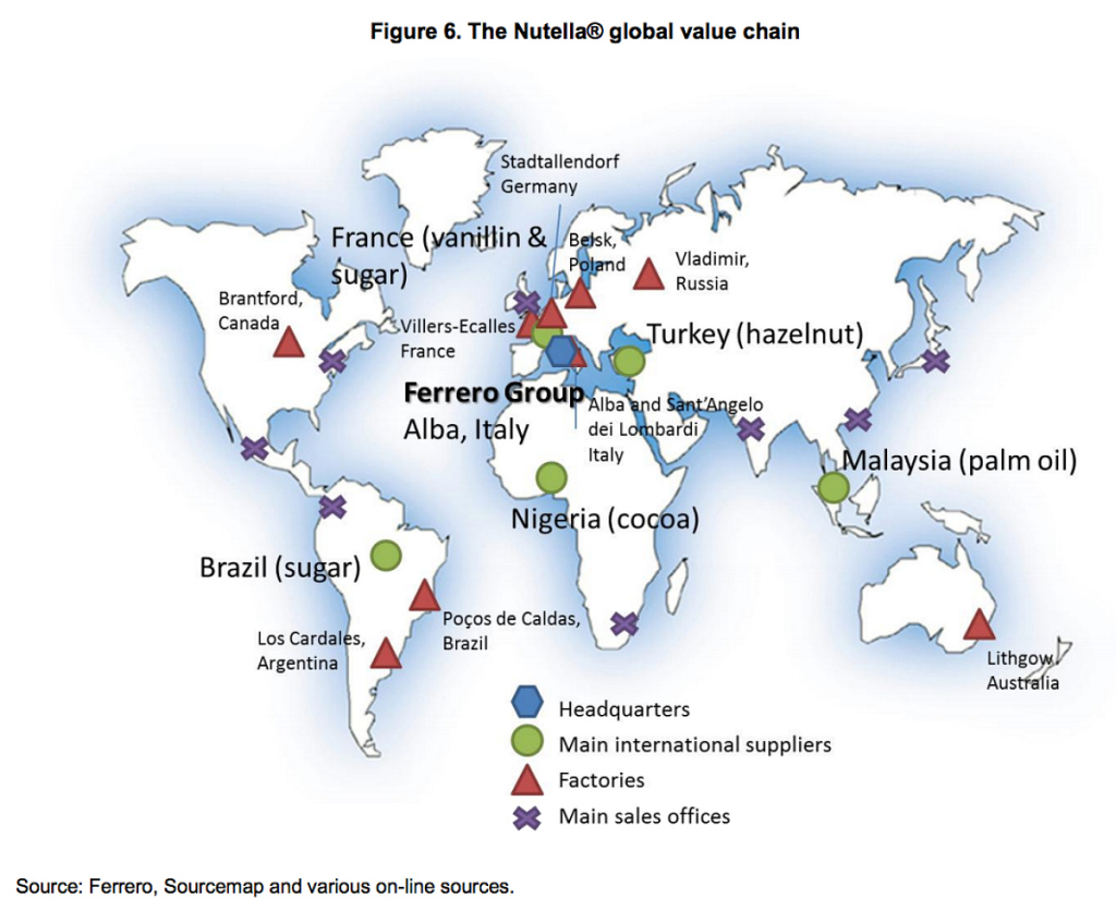
Source: http://www.theatlantic.com/business/archive/2013/12/map-all-the-countries-that-contribute-to-a-single-jar-of-nutella/282252/
Global participation
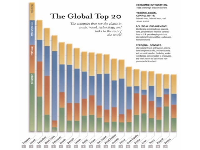
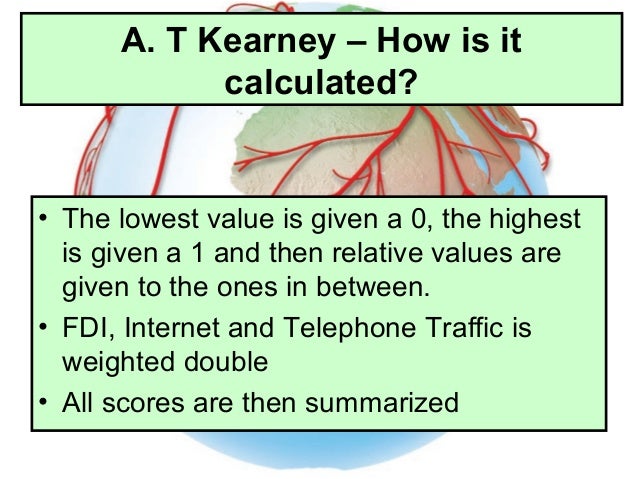
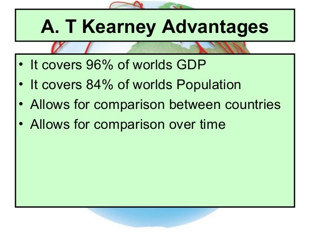
The Kearney index
The Kerney globalization index tracks and accesses changes in four key components of global integration (POLITICAL ENGAGEMENT, TECHNOLOGICAL ACTIVITY, PERSONAL CONTACT, ECONOMIC INTEGRATION). The index cover major regions of the world, including developed and developing countries, to provide a comprehensive and comparative view of global integration.
Source: Nagle, Garrett and Briony Cooke. Geography Course Companion. Print.
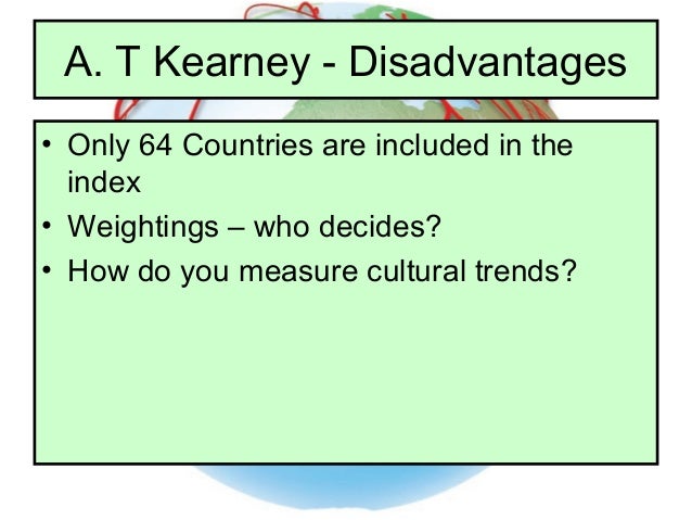
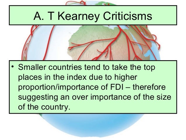
Source: http://pt.slideshare.net/mrLandi/comparing-kof-kearney
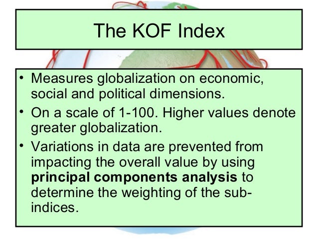
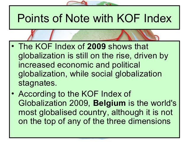
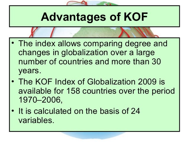
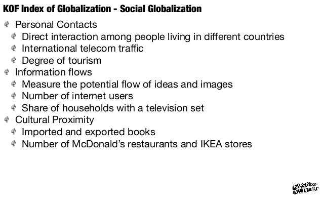
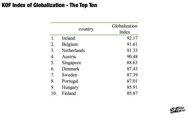
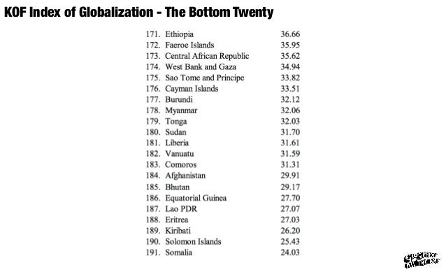
The KOF index
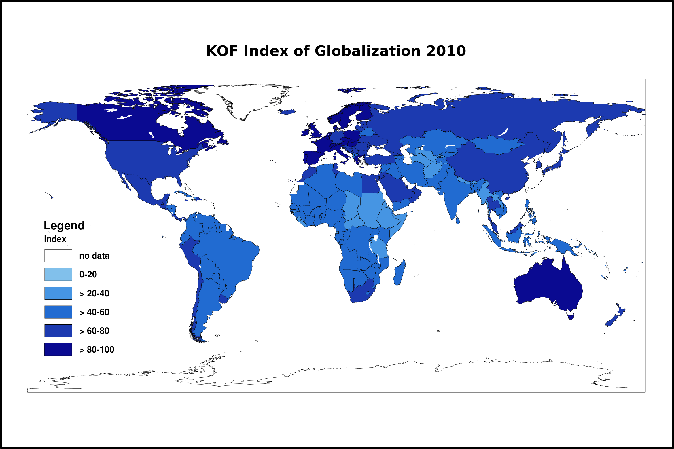
Source: http://share.nanjing-school.com/dpgeography/hl-course/hl-global-interactions/measuring-global-interactions/
The KOF index of globalization, introduced in 2002, cover the economic, social and political dimensions of globalization. KOF defines globalization as: "the process of creating networks of connections among actors at multi-continental distances, mediated through a variety of flows including people, information and ideas, capital and goods. Globalization is conceptualized as a process that erodes national boundaries, integrates national economies, cultures, technologies and governance and produces complex relations of mutual interdependence".
More specifically, the three dimension of the KOF index are defined as:
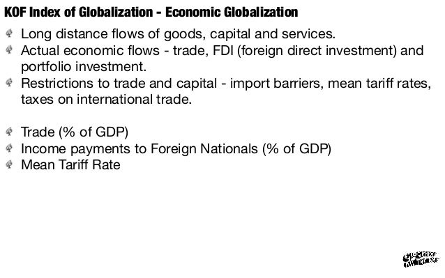
- Economic globalization, characterized as long-distance flows of goods, capital and services, as well as information and perceptions that accompany market exchanges (this accounts for 38% of the globalization index)
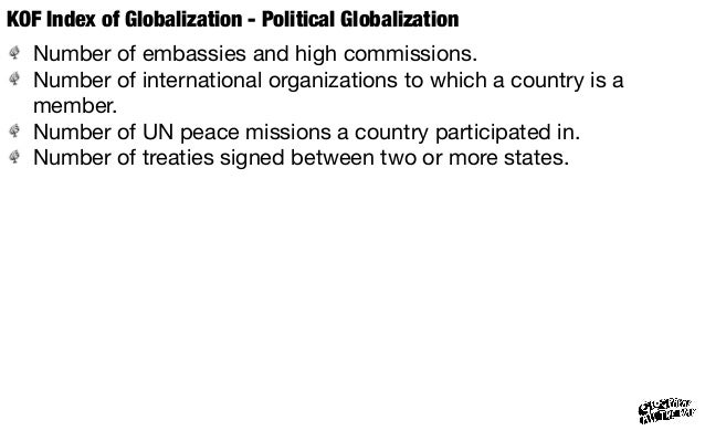
- Political globalization, characterized by a diffusion of government policies (this accounts for 23% of the globalization index)
- Social globalization, expressed as the spread of ideas, information, images and people (this accounts for the remaining 39% of the globalization index)
Source: Nagle, Garrett and Briony Cooke. Geography Course Companion. Print.
Source: http://pt.slideshare.net/mrLandi/comparing-kof-kearney
Source: http://www.geographyalltheway.com/in/ib-global-interactions/globalization-index.htm
Global core and periphery
The Theory of Core and Periphery
The basic principle of the 'Core-Periphery' theory is that as general prosperity grows worldwide, the majority of that growth is enjoyed by a 'core' region of wealthy countries despite being severely outnumbered in population by those in a 'periphery' that are ignored.
There are many reasons why this global structure has formed, but generally there are many barriers, physical and political, that prevent the poorer citizens of the world from participating in global relations.
The disparity of wealth between core and periphery countries is staggering, with 15% of the global population enjoying 75% of the world's annual income.
The Core
The 'core' consists of Europe (excluding Russia, Ukraine, and Belarus) , the United States, Canada, Australia, New Zealand, Japan, South Korea, and Israel. Within this region is where most of the positive characteristics of globalization typically occur: transnational links, modern development (i.e. higher wages, access to healthcare, adequate food/water/shelter), scientific innovation, and increasing economic prosperity. These countries also tend to be highly industrialized and have a rapidly-growing service (tertiary) sector.
The top twenty countries ranked by the United Nations Human Development Index are all in the core. However, of note is the slowing, stagnant, and occasionally declining population growth of these countries.
The opportunities created by these advantages perpetuate a world driven by individuals in the core. People in positions of power and influence around the world are often brought up or educated in the core (nearly 90% of world "leaders" have a degree from a Western university).
The Periphery
The 'periphery' consists of the countries in the rest of the world: Africa, South America, Asia (excluding Japan and South Korea), and Russia and many of its neighbors. Although some parts of this area exhibit positive development (especially Pacific Rim locations in China), it is generally characterized by extreme poverty and a low standard of living. Health care is non-existent in many places, there is less access to potable water than in the industrialized core, and poor infrastructure engenders slum conditions.
Population is skyrocketing in the periphery because of a number of contributing factors including a limited ability to move and the use of children as means to support a family, among others. (Learn more about Population growth and the demographic transition.)
Many people living in rural areas perceive opportunities in cities and take action to migrate there, even though there are not enough jobs or housing to support them. Over one billion people now live in slum conditions, and the majority of population growth around the world is occurring in the periphery.
The rural-to-urban migration and high birth rates of the periphery are creating both megacities, urban areas with over 8 million people, and hypercities, urban areas with over 20 million people. These cities, such as Mexico City or Manila, have little infrastructure and feature rampant crime, massive unemployment, and a huge informal sector.
Source: http://geography.about.com/od/politicalgeography/a/coreperiphery.htm

Source: https://popeaphumangeog.wordpress.com/2015/01/

In 1986 John Friedmann developed the world cities hypothesis. It was an attempt to understand the major global cities of the world and their response to the shift from an international to a global economy. Friedmann defined world cities as:
- centers through which money, information and commodities flow
- large, urbanized regions defined by dense patterns of interaction
- hierarchical with respect to the economic power they command and their ability to attract global investiment
- sites for the concentration and accumulation of capital
World cities have been created by a shift from an international to a global economy. An international economy sees good and services traded accross boundaries by individuals and firms from different countries under strict control of individual nations. However, in the global economy goods and services are produced by large multinational corporations (MNCs) who largely dictate the industrial policy of the nation state. They usually orchestrate their operations from world cities
Source: Nagle, Garrett and Briony Cooke. Geography Course Companion. Print.
Networks
Hubs and Nodes is a geographic model explaining how linked regions can co-operate to fulfill elements of an industry's value chain and collectively gain sufficient mass to drive innovation growth. The model of hubs and nodes builds on Porter's cluster model which served well in the past, but as businesses and regions around the world have adjusted to the realities of globalization, the concept of clusters is becoming outdated.
Source: http://broom02.revolvy.com/main/index.php?s=Hubs%20and%20Nodes&item_type=topic
OpenFlights/Airline Route Mapper
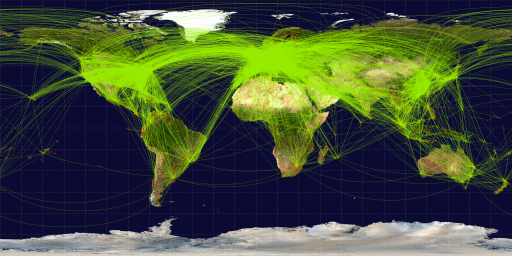
Source: http://openflights.org/data.html#route
No comments:
Post a Comment